
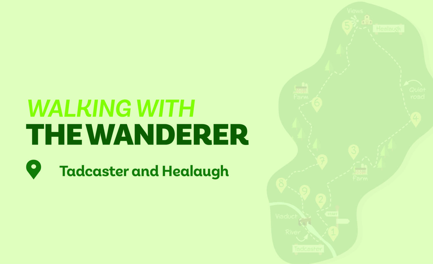
There are a number of good walks from Tadcaster but this is perhaps the best. Starting in the town, it heads east then north to the remarkably unspoilt village of Healaugh before turning back on an easily followed track. The final stretch joins the river crossing it on the imposing viaduct, now a foot and cycle way.
Is This Walk For Me?
Although seven miles long, this is an undemanding walk. The terrain is almost entirely flat but can be muddy, especially after Direction Point 3. On the roadside section (Direction Point 4) there is virtually no traffic. The path beside the river (Direction Point 9) may be impassable after flooding, in which case follow either the road or cycle path beyond the viaduct into Tadcaster. There are two stiles near the end which can be avoided by remaining on the road at Direction Point 8.
Getting There
The recommended starting point is the free public carpark at the bus station just before the river bridge in the centre of Tadcaster. Tadcaster is ten miles from York via the A64. Regular Coastliner 840 and 843 buses operate from several stops in York to Tadcaster bus station.
Refreshments
There are plentiful pubs and a few cafes in Tadcaster but no options en route.
What To See
Soon after the start, the walk parallels Catterton Rush; an area of native woodland awash with bluebells in spring. Healaugh is one of the Vale of York’s most unspoilt villages with a range of individual house styles and an ancient church set on a small hill with good views. The return to Tadcaster follows a track across well cared for farmland. The impressive viaduct in Tadcaster is a curious feature, never having been used as part of a mainline railway.
Download your FREE digital walking route map!
1. Leave the carpark/bus station on the right side of the waiting area and cross the main road at pedestrian lights. Turn right uphill to traffic lights. Then turn left (Wighill Lane). Follow this through bends for about 300-metres. Just after trees and open land appear to the left, find a stoned track on the right. It is a signed bridleway that leads beside an older house.
2. Follow this track as it soon bends to the left. You will pass a farm, then a house to the right. Shortly after a right-hand bend, reach a track junction. Here, keep ahead (right) on an earth track, soon between hedges. Ignore a field path left to approach a farm.
3. Do not go right with the track towards the house, but instead walk diagonally across an open area heading to the right of an open-sided barn to find a track. Follow this with a wire fence to the right for a short distance until you reach a concrete bridge. Do not cross but instead turn right on a narrow path with a fence right. The path soon goes left over a footbridge into a large, usually cultivated, field. The official right-of-way heads straight on over the field. However, it is easier to follow the practice of most walkers and turn right alongside the stream to the field corner. Here turn left (do not go ahead) with the wood to the right. Continue for about 700 metres until the wood ends. Keep ahead on the path that widens to a track. Continue to reach a tarmac road.
4. Turn left on the road following it between hedges and through bends for over 1,500 metres to the edge of Healaugh village. At the road junction in the village keep ahead (left) on the main street between the older houses. Remain on the street as it bends left and right to exit the village with the church on its hillock to the right (to visit the church take the gravel path at the first bend).
5. About 175-metres beyond the right bend look out for an unsigned track on the left guarded by a green metal barrier. Take this track (it’s a public bridleway) passing a wood to the right. Ignore a signed footpath right staying on the track as it later angles sharply right. At a T-junction go right again (not through the gates with the yellow arrow). Continue to a metal barrier, keeping ahead on a short stretch of tarmac with houses and farm buildings right.
6. At the end of the buildings pass another barrier and continue on the hedged track. This soon goes left then passes through a series of double bends. About 200 metres beyond a small wood (on the left) reach a track T-junction with a hedge gap to your left.
7. Here, be sure to turn right (permissive footpath notice). Pass another metal barrier and ignore a drive to a house on the right, eventually reaching a road.
8. Turn left on the narrow pavement. In about 400-metres find a gate/stile in the wall on the opposite side of the road.
9. Go over and walk diagonally across the field to the far corner. Cross another stile and follow the riverside path to the viaduct. Pass under this and then ascend the steps to cross over the viaduct. On the other side descend steps then enter the grassy field keeping ahead to the river bank. Now follow the riverside path which soon becomes paved. Pass the church and continue to the main road at the river bridge. Cross and return to the carpark/bus station.
Please note: Walks are undertaken at your own risk. Due care must be taken in following the walk, particularly after poor weather. Whilst every care is taken in compiling the description, some changes may have occurred since publication. Neither the walk author nor Your Local Link can accept any responsibility for any errors or omissions.


Paul haw
21 May 2024 at 16:20Is it possible to get older walks from your site
Add a comment