
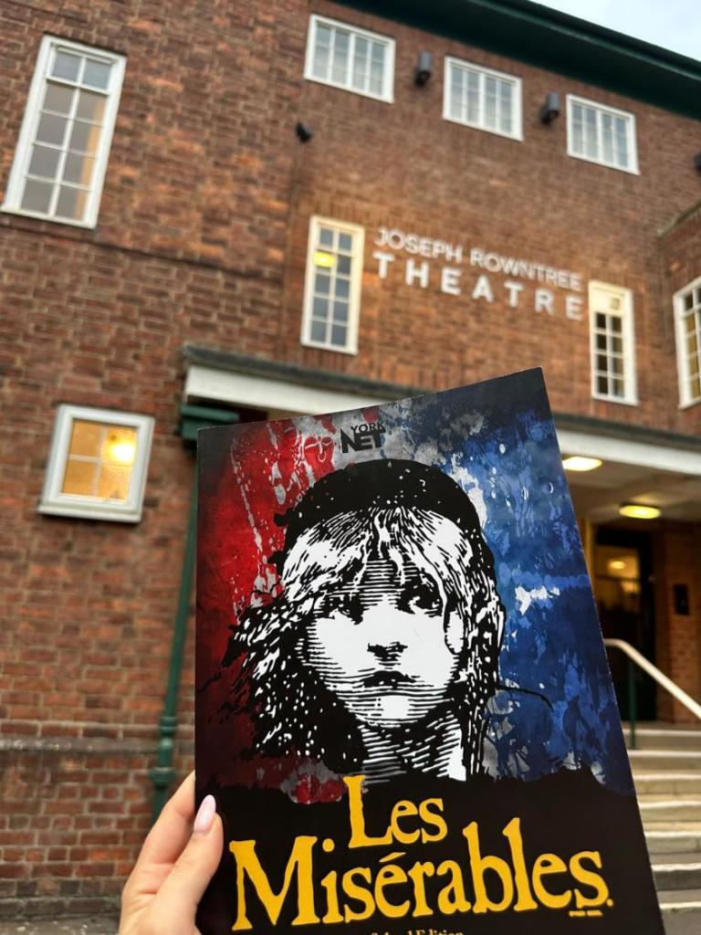
Huggate West Walk
Huggate is a popular Wolds walking hub. This route heads west from the village across quiet field paths, valley rim pastures, and an old bridleway. The landscape is typical of the high Wolds and has the added bonus of far-reaching views to the east and south.
Is This Walk For Me?
For a Wolds walk, this is relatively flat. There are a few ups and downs but only one slope— a short descent near the start— is steep. There are no stiles and only one section of road walking, near the end on a quiet stretch. Mud may be encountered at this time of year so some paths can be slippery. Farm animals graze in some of the valley pastures. Route finding should be easy as waymarks are good throughout.
Getting There
The starting point is the free car park on the eastern edge of Huggate, off Driffield Road just beyond the Wolds Inn. Huggate is 20 miles from York following the A166 through Stamford Bridge and turning off after Garrowby Hill at the Wayrham picnic area. Unfortunately, there are no public transport options for this walk.
Refreshments
The Wolds Inn, near the start point, offers bar and restaurant food as well as drinks. It is open daily, Wednesday through to Sunday. Rachel’s Walnut Cottage Tea Room in Huggate (turn left at Direction Point 7) provides light refreshments and is open Saturday through to Tuesday 11am-4pm.
What To See
The countryside around Huggate offers archetypal high Wolds scenery. The higher farmed land is split by deep dry valleys flanked by steep grassy slopes. Large farms, often clothed by shelter belts, and a few woods dot the landscape. From the high ground, there are extensive views east and south, as well as down into the deep valleys, especially Pasture Dale at Direction Point 4. Huggate is a quiet village off the beaten track. Its old well is said to have been one of the deepest in the country.
Download your FREE digital walk map!
1. Turn right out of the car park. In a few metres ignore the public footpath right, but about 20 metres beyond it take the alternative permissive path going through a kissing gate. Quickly pass through another gate then head half-left across the hummocky field on a sketchy grass path towards a third gate. After passing through the gate, take the lane slightly to the left to walk over the green (with a seat and goalposts left). Once you reach the road, turn right and head downhill, passing the church to the right.
2. After the last house on the left, take the signed path going half-left across the sloping field, soon descending steeply to a gate in the far-left corner. Turn left on the fenced track. Where this curves right towards a farm, keep ahead on a signed path (initially with a hedge on the right). Continue until this narrow path joins a track coming from the farm. Keep ahead (away from the farm) then at a signed footpath junction keep left on the track which, in a further 400 metres, reaches a road.
3. Cross straight over the road by following a field-edge track. Where the hedge on the left ends, turn left (as signed by a grassy path between fields). Remain on this path, which eventually has a sporadic hedge on the right, to reach a gate at a road junction.
4. Turn right, being sure to take the further (uppermost) road (signed Wolds Way). In about 150 metres go through a gate on the right and walk alongside trees to the left and a deep valley right. Where the trees end, keep ahead above the valley, soon curving right and gradually descending. Remain above the valley with a fence to your left until you reach the corner of a wood. Here, turn left on an enclosed path with the wood right. At the next gate go right for about 100 metres alongside the wood to reach a further gate.
5. Do not go ahead here but instead turn sharp left to follow a faint grassy path (this is open access land so there is no footpath sign) close to the fence on the left. Continue, soon with gorse bushes and the deep valley right, until a wooden gate is visible ahead. Do not go through this but turn right beside the fence to find a metal gate at a bridleway sign. Go through and take the path left following power lines. Keep going ahead to reach an isolated house at a road.
6. Cross the road and take the signed bridleway opposite. Now continue on this path, ignoring all ways off. Initially, there’s a deep valley on the right and later a young plantation at the head of a further deep valley. After nearly 2,000 metres, the bridleway reaches a road.
7. Turn left on the road, which soon becomes tree-lined, for about 1,000 metres until you reach the staggered crossroads at the centre of Huggate. Turn right (left if visiting Rachel’s Tearoom), soon passing the Wolds Inn, to return to the car park.


Add a comment