
This short walk is packed with interest. Starting at the attractive village of Gilling East it follows a quiet lane with views across to Ampleforth Abbey. Crossing fields to reach the edge of Ampleforth village it then passes the Abbey, which is open to visitors, before heading back to Gilling East across the extensive playing fields of Ampleforth School. The entire walk is a little over five miles and is easy to follow. Much of the route is on good surfaces with only a couple of potentially muddy areas.
GETTING THERE
By car Gilling East is 18 miles north of York on the B1363. There should be space to park considerately on the main street near the Fairfax Arms. No buses run to Gilling East but service 31X from York Exhibition Square passes through Ampleforth two or three times a day. If taking the bus to Ampleforth you start the walk by turning from Station Road into St Hilda’s Walk (point 3 of the directions).
REFRESHMENTS
The Fairfax Arms in Gilling East is open all day and serves food at lunch time and in the evenings. The Abbey Tea Room at Ampleforth is open to 5.30pm. To find it (it’s not well signposted from the grounds) aim for the steps in front of the Abbey and follow the signs for Reception.
WHAT TO SEE
Gilling East is an attractive stone built village on the edge of the Howardian Hills with an ancient church. On the route out of the village you pass both the model railway run by the Ryedale Society of Model Engineers and a new social enterprise making bespoke chocolates (visitors welcome when open). Ampleforth Abbey is visible on the hillside for a large part of the walk. The Abbey Church, shop and café are open to visitors. On the hillside to the left on the return to Gilling East are glimpses of one of Anthony Gormley’s ‘Man’ sculptures (Gormely attended Ampleforth Abbey School).
1. At the Fairfax Arms take the road at the side of the pub, Pottergate. Continue down this quiet tarmac road ignoring all ways off, soon with view across the valley to Ampleforth Abbey on the right. Pass old farm buildings on the right housing a chocolatier (visitors welcome) and a sign ‘wildlife sanctuary’ on the left. Keep on the road as the surface roughens ignoring a private road to the right to continue on what has become a track. Follow this to the right at another wildlife sanctuary sign after which the track soon swings left.
2. About 75 metres beyond this left bend turn right through a gate (there’s a footpath sign opposite pointing the way partly hidden under a small tree). Beyond the gate follow the left edge of the field to another gate. Go through this following a sign to Ampleforth into a wooded area. Cross a plank bridge (this area can be muddy) and continue through the trees to emerge into a field. Go ahead along its left boundary following the path as it kinks right then left, still with open fields to the right. Eventually you come to a play area where you go straight on to reach houses at a road. Continue ahead uphill towards Ampleforth village.
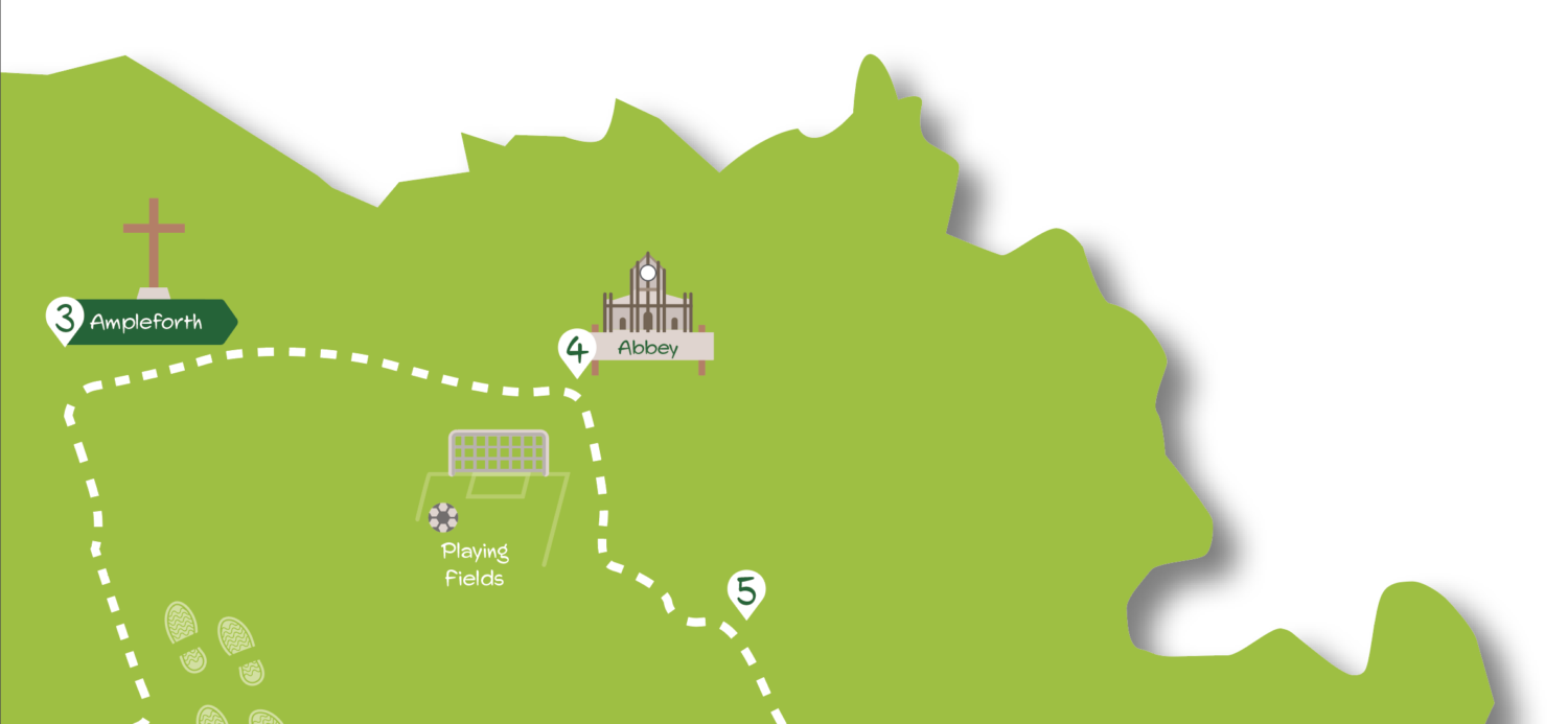
3. Soon after a school on the left turn right into St Hilda’s Walk. Continue to pass the surgery and at another school on the right keep left where the road forks onto a stony track. Ignore a track to left and continue ahead. The track soon joins a tarmac road with houses on the right then a carpark to the left. Coming to the Abbey grounds continue on the tarmac drive with the abbey Church uphill to your left (to visit the Abbey and its tea room zigzag up the tarmac paths and go up the steps).
4. To continue the walk, where the tarmac drive comes to a cross tarmac track go right downhill through a gate following footpath waymarks towards an obvious cricket pavilion (if visiting the Abbey and tea room you need to zigzag back down the tarmac paths to this point). Continue on the tarmac road as it swings left. Soon after this at a three way junction take the middle tarmac track that quickly turns to the right to a gate marked ‘Tip Area’. Take the grassy track and at the end of the nets on the bank above turn sharp left at the bottom of a bank. Continue ahead into an area of young trees following a grassy path. Soon cross a bridge to a gate.
5. Here take the lower of the signed paths into the rough pasture heading half left slightly up the slope. Here you should soon find a marker post that points the way ahead over the crest of the slope towards a stile in the treeline at the far edge of the pasture. Head for the stile and climb over (the area near it can be muddy) to immediately cross a bridge over a beck. Here you can go ahead over the field but the easiest return is to turn left following the beck on the field edge. At the end of the field go through a metal gate and continue on alongside the left edge of the next field to a wooden gate. Pass through this and follow the short track to the road. Here turn right to quickly return to the Gilling East.downhill). Continue into the church grounds going to the right of the church taking the alleyway ahead back to the station.
DISCLAIMER: Walks are undertaken at your own risk. Due care must be taken in following the walk, particularly after poor weather. Whilst every care is taken in compiling the description changes may have occurred since publication. Neither the walk author nor Your Local Link can accept any responsibility for errors or omissions.


Add a comment