
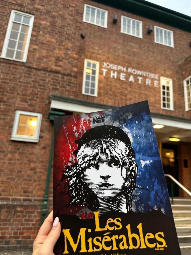
A long walk through Bugthorpe and Kirby Underdale. 7 miles // 4 hours.
This walk explores an area of secluded countryside at the foot of the Wolds, much of it part of the Garrowby Estate. Starting from Bugthorpe, the route follows field paths and tracks over undulating terrain to arrive at Kirby Underdale. From here it’s a flatter route back to Bugthorpe, at first on a field path then a country road that carries little traffic.
While not incredibly strenuous, this is a slightly more adventurous route than some, much of it on paths that are lightly used. There are several potentially very muddy and wet sections, so appropriate footwear is essential. Although generally well signed, there are a few points where the route isn’t obvious. These are underlined in the Directions.
Getting There
The recommended start point is Bugthorpe, where there’s ample roadside parking near the church. It’s also possible to begin the walk in Kirby Underdale. Bugthorpe is 13 miles east of York. Take the A166 from the Grimston Bar interchange turning left three miles east of Stamford Bridge on a country road. No bus routes pass through Bugthorpe.
Refreshments
Bugthorpe Post Office offers hot and cold drinks to go.
Directions
1/ Starting with Bugthorpe church behind you, go left at the end of the churchyard then keep to the green on the right going along its top to arrive at a T junction with a grass triangle. Turn left here down the road. Where this swings left into Low Hall go ahead on a narrow signed path. At a gate go half left across the grass field to another gate and bridge over a stream. Climb the steps and go through the gate to go along the right edge of the field to a wooden gate. Once through continue, keeping near the stream to the right field corner. Go through a new gate and head left uphill as signed with a hedge to the left to reach a grassy track.
2/ Turn right on the track but in about 100 metres turn left (yellow arrow) along the edge of a large field with a hedge on the right. Continue following the hedge around several doglegs to the far right-hand corner of the field. Here turn right through a hedge gap as signed, now with a hedge to the left. Continue ahead through further fields keeping to their left edge. Where a path comes in from the right (blue arrows), keep ahead but in 50 metres where the hedge goes left follow it uphill. Through a gate continue into the next big field climbing gradually with the hedge still to the left. At the top of the field go right on the other side of a hedge to a gate. Continue with a house to the right to a driveway. Turn left down this but in about 100 metres, at the end of the wooden fence on the right, find a signed path at a metal gate.
3/ Go through the gate and turn half-right downhill, keeping near a wire fence to the right. At the lowest point of the field by a ford go over a plank bridge across the stream. Keep left in the small grassy area to go uphill into a large field with a tall hedge to the right. Where the hedge ends, keep ahead through a gate along the left hedge of the next field. At the copse turn left as signed through a gate, then swing beside the trees keeping them to the right. Continue alongside the trees uphill. Where the trees end keep straight ahead across the grass to an unfenced road.
4/ Turn right down the road but in 100 metres turn left on a signed path with a wooden fence to the right. Go through a gate and continue, slightly left, across a humpy field to another gate (yellow arrow) below the farm on the bank above. Keep ahead across the field guided by a solitary wooden marker post set in the grass. Continue, gradually nearing the hedge on the right to the far right corner of the field. Here go through a gate and head half right downhill through a boggy area. Keep parallel to the hedge on the right to go into the corner of the V-shaped field and a kissing gate. Through the gate cross the small stream (this can be tricky!) and continue in the next field alongside the hedge to the right. At the next gate keep ahead (left of a few trees) on a grassy track across the field. After a further gate, where a better track joins from the left, keep ahead. Follow this clear track into a dip then as it swings left and right over a cattle grid and across another field to a further cattle grid and a road.
5/ Turn right on the road downhill, passing a cottage and going round a left bend. Follow the road to a junction. Keep left here and continue to the edge of Kirby Underdale passing the village hall and car park (alternative starting point). To visit the small village and church go left down the main street passing houses to either side. The church can be accessed via a discreet metal gate on the left.
6/ To continue the walk (or on returning from the church) take the signed footpath just before the start of the village leading across a gravelled area to the right of the village hall. Go through a gate and slightly right in the grass field downhill to a gate to the left of a bend in the hedgerow. Through the gate continue along the right edge of two fields. At the end of the second field pass through a kissing gate, then veer right down to the field corner. Turn left here with the hedge/ditch to the right. Continue to another kissing gate in the far right corner of the field. Through the gate proceed in the same direction to arrive at a track leading to a farm on the left. Go through a kissing gate opposite and continue along the right edge of the field. Leave the field at another kissing gate to head across the grass to a roadside footpath sign.
7/ Turn left on the quiet road, often with wide verges. This is followed for over a mile back to the starting point in Bugthorpe.
What To See
Bugthorpe and Kirby Underdale are small unspoilt villages away from busy roads. Both have historic churches, with All Saints Kirby Underdale having an especially fine setting on top of a steep rise overlooking the Wolds. At several points on the walk, the route crosses fields with humps and bumps indicating previous cultivation and settlement. Near the start at Bugthorpe are the remnants of moats and at Point 4 in the directions, the route passes the site of Hanging Grimston, a deserted mediaeval village recently excavated as part of a community archaeology project.
Disclaimer
Walks are undertaken at your own risk. Due care must be taken in following the walk, particularly after poor weather. Whilst every care is taken in compiling the description, changes may have occurred since publication. Neither the walk author nor LocalLink can accept any responsibility for errors or omissions.


Add a comment