
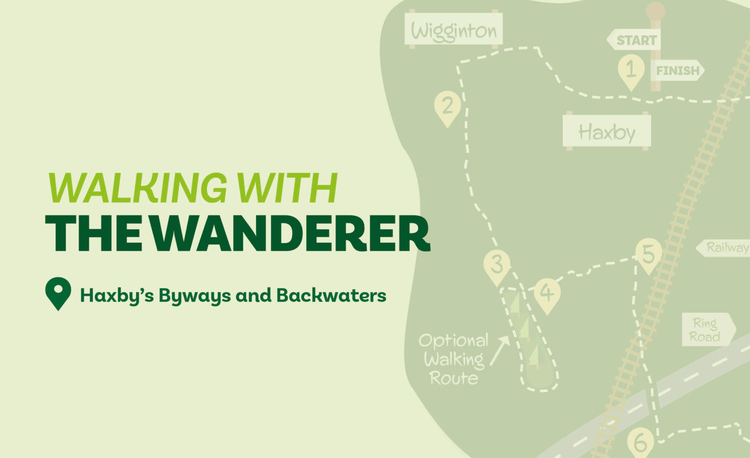
Starting from the centre of Haxby, on this walk you’ll visit Wigginton before taking an old farm track to reach a newly created woodland managed by the Woodland Trust. After negotiating alleys and Haxby’s southern outskirts, the route arrives at the River Foss by Huntington Church. The river is then followed for one-and-a-half miles back to Haxby.
Is This Walk For Me?
This is an easy, flat, walk. Although there are a few potentially muddy stretches, most of the route is on hard surfaces— making it suitable for a winter outing.
Getting There
The recommended starting point is Haxby Memorial Hall opposite a shopping parade on The Village. It would also be possible to start the walk at several other points, including from Earswick and Huntington by crossing the Foss. Haxby is four miles north of York following Haxby Road from Gillygate. There are frequent buses to Haxby, the most convenient is no.1 which is avaliable from the station and Theatre Royal. Alight opposite Haxby Memorial Hall.
Refreshments
There are numerous options in Haxby & Wigginton including The Black Horse in Wigginton.
What To See
Although the route follows close to houses and roads it has a surprisingly rural feel. Westfield Wood, managed by the Woodland Trust is a good example of recently created native species woodland. The pleasant walk alongside the Foss provides an opportunity to see a range of wildlife. More information on what may be seen is available on the Rover Foss Society’s website at riverfosssociety.co.uk
Download your FREE digital walk map!
1. With the Co-op supermarket behind you and the Memorial Hall opposite, go left along the main street (The Village), soon passing the Tiger Inn. Continue for about 700 metres until just beyond the Cottage Inn, then take the signed public footpath on your left between the fences. Keep ahead at a barrier, then go left before turning almost immediately right following Back Lane (with the church left). Go right at the next junction (still Back Lane) but in 50-metres turn left. Pass the school but as the road bends left keep on a track to the right of the houses.
2. Follow the track with houses to the left and fields to the right. Keep going as it narrows and partly runs between hedges (ignoring a way off to the left). Eventually you’ll arrive at a kissing gate on the edge of Westfield Wood.
3. Enter the wood. For the shortest route take the left path through the trees which takes you straight to Direction Point 4. To walk through the wood take either of the paths to the right. The rightmost keeps to the wood-edge which is closest to the fields on the right, before turning left at the right corner. The middle path takes a clear route through the wood. Both meet at the wood’s far corner. Once there, do not follow the path right but go left for a few metres — towards the houses opposite, to reach a ditch. Turn left to walk alongside the ditch with houses over to the right and the wood left. Both this path and the shortest route meet at a footpath sign by a redundant kissing gate.
4. At the footpath sign go left (right if you’ve taken the longer walk through the wood) crossing the ditch to follow a path between gardens. Cross a road and keep ahead on the path between houses. At a metal gate go right then left. Keep ahead and cross the road in front of houses to continue on the path as it angles left to reach some barriers. Next turn right through the parking area, cross a road, and then keep ahead on a tarmac footpath before you pass through further barriers to arrive at the main road.
5. Turn right on the road. Cross and continue over a mini roundabout and level crossing, then take the underpass beneath the ring road. 125 metres later you’ll see a sign for Tregarth Stables, at this point you should turn left on an enclosed path.
6. Follow this to a gate, pass through and continue for a short distance until you reach a signpost at a crossing track. Turn right here, then after 50 metres —where the hedge to the left ends— go half-left to move diagonally across the field aiming towards the left of the trees by a pylon. You’ll reach a kissing gate. In the next field continue to move diagonally across the grass to reach the river.
7. Turn left and follow the river right. Continue in the same direction for about a kilometre to pass under the ring-road bridge beyond which you’ll soon find a footbridge.
8. Cross the bridge and turn left onto the riverside path. Continue beside the river with a park like area to the right until you reach another bridge. Cross here and follow the clear path in front of you with a fence and house left and the river to the right. Remain on this path until it turns away from the river to meet a concrete track. Turn right and continue until you reach houses and a road junction.
9. Then turn left, continuing over the level crossing to a roundabout. Go straight over to arrive back at the starting point.
Walks are undertaken at your own risk. Due care must be taken in following the walk, particularly after poor weather. Whilst every care is taken in compiling the description, some changes may have occurred since publication. Neither the walk author nor Your Local Link can accept any responsibility for any errors or omissions.


Add a comment