Wharram Percy
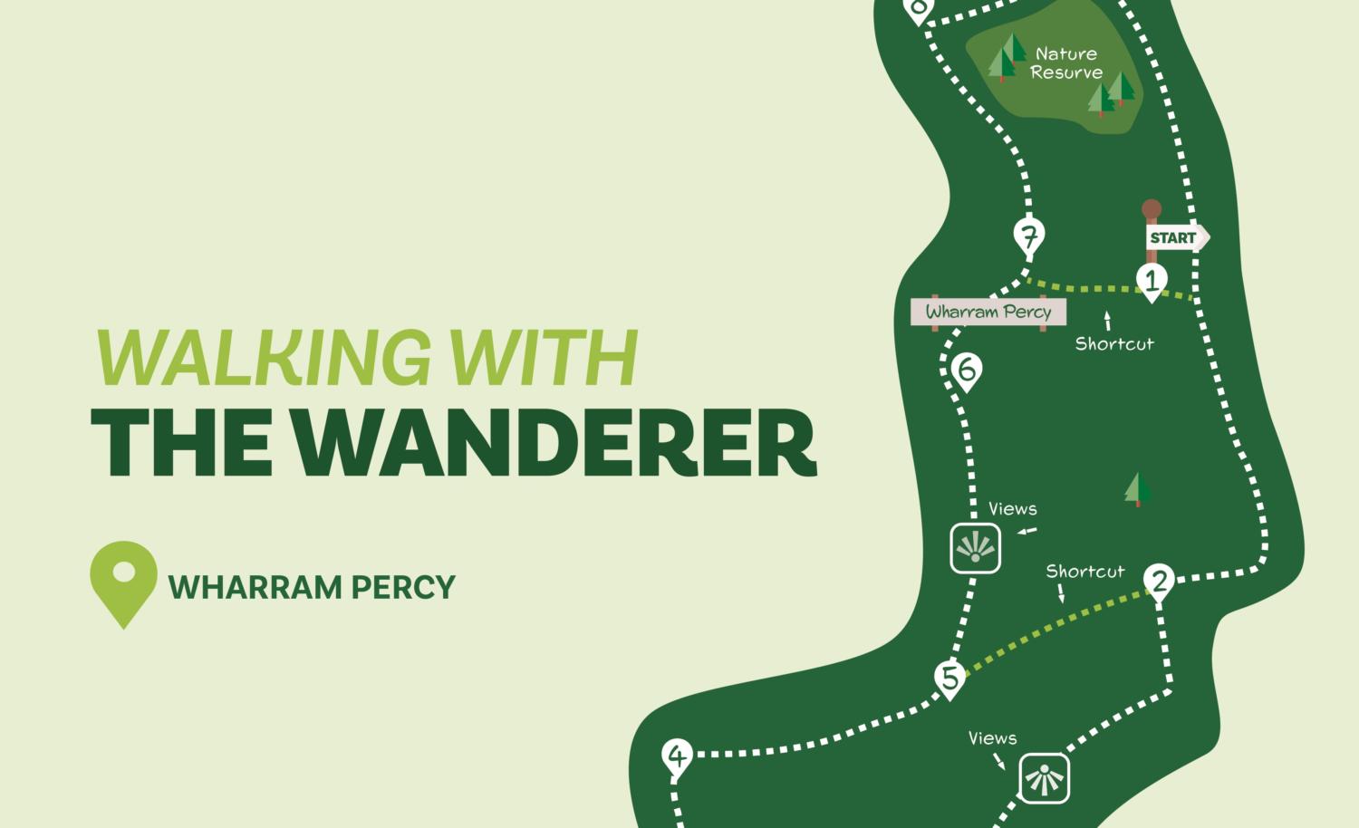
This walk visits a quiet area of the Wolds. A short climb is rewarded with far-ranging views across East Yorkshire. The route then traverses typical Wolds farming country to follow a deep valley to the deserted village of Wharram Percy. There’s also an opportunity to visit Yorkshire Wildlife Trust’s Wharram Quarry nature reserve. The full walk can be shortened by omitting Direction Points 2-4 and/or returning to the car park at Direction Point 7.
Distance: 6 Miles
Time (approx): 2 hours 45 mins
Is this walk for me?
the walk includes a number of climbs most of which are long rather than steep. There are no stiles to cross. Cattle may be grazing in the valley above Wharram Percy. Some of the field edge paths at Direction Point 2 may be overgrown.
Getting there
The starting point is the English Heritage car park (fee requested) near Bella Farm about one mile from Wharram le Street. There are several possible routes from York varying between 23 and 26 miles. The recommended route is to take the A166 to Fridaythorpe turning left then right in the village to follow Church Lane to Burdale. At Burdale turn left. Unfortunately, there are no public transport options for this walk.
Refreshments
There are no refreshment opportunities on this route. There are pubs at Thixendale and North Grimston and a pub and café at Fridaythorpe. Check websites for opening times.
What to see
The highlight of the walk is the site of the deserted medieval village of Wharram Percy, one of the most extensively excavated such sites in the country. English Heritage interpretation boards provide extensive information. Nearby is the Yorkshire Wildlife Trust Wharram Quarry nature reserve where chalk-loving plants and butterflies can be found in late spring and summer. The walk provides far-reaching views at several points, especially near the start and approaching Wharram Percy.
Download the route map
Directions
1. From the car park entrance go right on the road, uphill. Continue to the top of the hill and a double bend. Here, go right off the road on a track signed ‘Centenary Way’. At the end of the trees on the right keep ahead with a hedge to the left on the now grassy track.
2. About 150 metres beyond the end of the trees take the signed bridleway to the left (for the shorter walk continue ahead for 750 metres until Direction Point 5). Walk along the field edge with the hedge on the right (this section can be overgrown) into the next field. Here continue in the same direction, still with the hedge to the right. At a wooden fence gap go right, now following a hedge right and with the sloping field left. Keep going in the next field, curving left downhill.
3. Reaching a ‘private’ sign, go right on a signed bridleway uphill with a hedge and trees to the left. At the end of the trees go right as signed with a hedge to the left. At a prominent mast, go left into the second of two fields with the hedge to the left. At the field end, turn right signed ‘Centenary Way’. Keep right of the hedge ahead to arrive at a gap in a wooden fence at the right edge of a line of trees.
4. Through the gap, turn right with a hedge and trees to the right and a field to the left. Through a metal gate continue ahead to another gate, now with trees to the right.
5. In about 600 metres, at another gate, do not go through it but turn left (if following the shorter walk from Direction Point 2 turn right here) as signed walking near to the hedge/fence with the valley of Deep Dale to the left. After a small dip, veer left as signed heading away from the fence downhill on a grassy path. Go through a kissing gate and keep ahead (right). Cross the pond dam and walk over the grass to find the ruined church ahead.
6. On the far side of the church, head to the left of the boarded-up house to pass through a kissing gate heading towards a wooden footpath sign beyond the fenced area. At the sign, turn right downhill on the track. Continue on the track to a kissing gate.
7. For the full walk, turn left after the gate on a track between trees (for a shorter walk returning to the car park in 600 metres go up the steps opposite). Continue on the track to pass a house on the left and arrive at a tarmac road.
8. Turn right on the road heading uphill (the entrance to the nature reserve is on the right in 75 metres.) Continue on the road until houses are on the right.
9. Just before the first house, turn right off the road on the signed ‘Wolds Way footpath’. Follow this alongside a hedge on the left to reach a road. Turn right on the road following it beyond Bella Farm to return to the car park entrance.
Disclaimer: Walks are undertaken at your own risk. Due care must be taken in following the walk, particularly after poor weather. Whilst every care is taken in compiling the description changes may have occurred since publication. Neither the walk author nor Your LocalLink can accept any responsibility for errors or omissions.


Add a comment