
Offering a mix of riverside walking, field paths and a long stretch along an old railway line, this walk explores the pleasant countryside east of Wetherby. It also provides an opportunity to see some of the sights of this prosperous market town, including the riverside.
Is This Walk For Me?
This is a generally unchallenging route, especially the long section on the old railway line. Mostly flat, it has no stiles but parts of the path approaching Wetherby can be rather overgrown in summer. Riverside sections may be impassable at times of flood. There is one section on a road with no pavement where care must be taken.
Getting There
The recommended starting point is Wetherby bus station. Bus 412 operates five return services to Wetherby from Piccadilly and the rail station daily (not Sunday). The last bus from Wetherby departs at 16.30. Wetherby is 15 miles west of York using the B1224. There are several carparks in Wetherby. The most convenient for the route is the Wilderness accessed via Bridge Foot which is the first turning on the right after the river bridge. It would also be possible to start in Thorp Arch where there is roadside parking.
Refreshments
There are numerous options in Wetherby otherwise the only option is the Pax Inn at Thorp Arch. The Pax is open daily but only from 4pm Monday to Wednesday.
What To See
In Wetherby there are a number of interesting streets and older buildings in the town centre including the Shambles. The return to the town follows the riverside and includes an opportunity to view the weir beyond the town bridge. Thorp Arch is an attractive stone built village. Otherwise the main attraction is the quiet countryside and the old railway line path which is bordered by a variety of interesting flora.
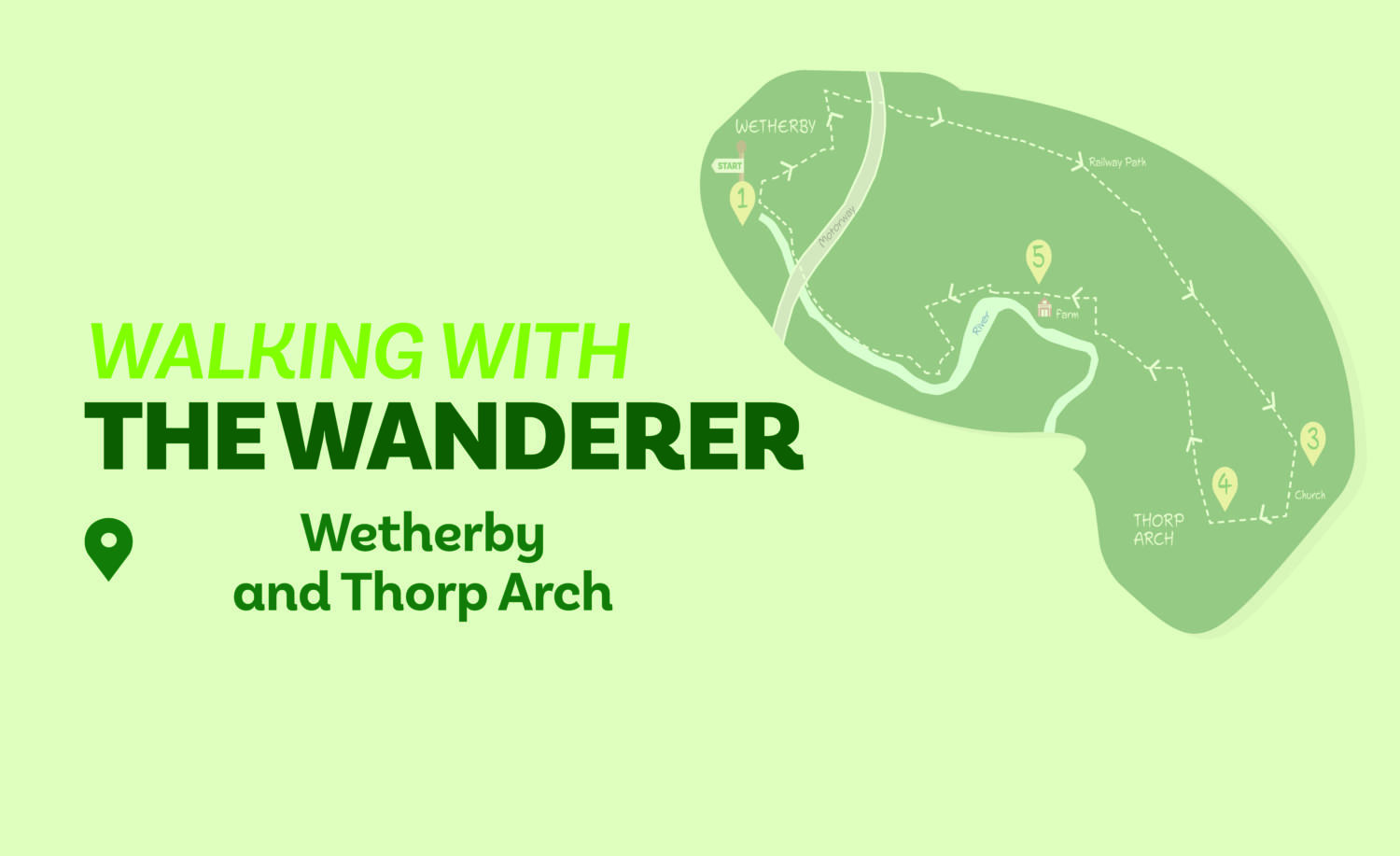
1/ From the bus station cross the road at the pedestrian lights and go left. Turn right into Cross St. Turn left at the end and cross over at the pedestrian lights ahead then go immediately right down Horsefair. (If starting from the riverside carpark follow the access road out and turn right onto High Street then right onto Horsefair). At the end cross over at pedestrian lights and walk up Hallfield Lane to the left. Stay on this as it bends hard left, continuing for about 400 metres until opposite Sadlers Walk. Here go right down Freemans Way. Where this bends right take the signed Wetherby Rail Path to the left.
2/ Now continue on this path for about two miles crossing over a tarmac track and then coming to a road. Here follow the signs to cross safely continuing on the cycle route to the left of Wood Lane. Pass under two bridges to arrive at a further road.
3/ Leave the cycle route here going right on the pavement. Continue ahead at a road junction. Opposite the church gate left take the unsigned path right going through a kissing gate. Follow the path along the left edge of the field and continue through several more fields passing through kissing gates and keeping close to the left boundaries. Pass a tennis court and after a final kissing gate take a rough track with houses right to reach Thorp Arch’s main street.
4/ Turn right and follow the road out of the village taking care as there is no pavement after the houses end. In about 700 metres leave the road at a footpath sign on the left. Go along a grassy track. At metal gates turn right, soon after going through a left bend to continue under a canopy of trees. Reaching a tarmac lane keep ahead towards buildings.
5/Where the tarmac goes right at the end of the buildings keep ahead (signed Ebor Way) following the left edge of two fields. Arriving at a tarmac track turn left (signed public footpath) continuing to the wastewater treatment works. Here take the track right with the river left. Where the track ends at a field, follow the path near the river.
6/ At the end of the long field go through a kissing gate and go under the motorway bridge. Almost immediately beyond this, fork left beside the river to pass under a further bridge. Stay beside the river to reach a carpark. To return to the bus station walk through the carpark close to the riverside exiting at its left corner. Go under the bridge. Just after this take the path right (continue ahead for a few metres for the best views of the weir) signed town centre, turning left to arrive back at the bus station.
Disclaimer
Walks are undertaken at your own risk. Due care must be taken in following the walk, particularly after poor weather. Whilst every care is taken in compiling the description changes may have occurred since publication. Neither the walk author nor Your Local Link can accept any responsibility for errors or omissions.


Add a comment