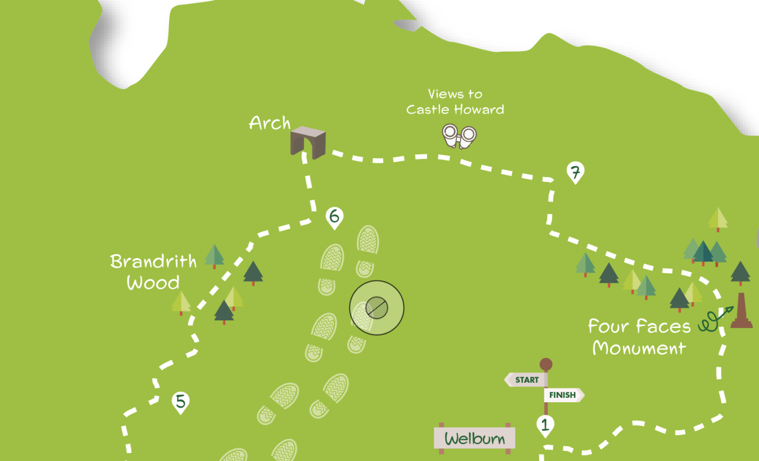
Walk your way through Welburn, Bulmer and the woods in-between.. With one exception, (underlined in the Directions), the walk is easy to follow with mainly well-waymarked paths and good surfaces underfoot.
Getting there
The recommended starting point is the centre of Welburn. Welburn is 14 miles from York just off the A64. There’s ample roadside parking on the village street. It’s also possible to park and start from Bulmer. Coastliner buses 840 and 843 run frequently from the railway station and Stonebow to near Welburn, stopping at the end of the lane leading to the village from the A64.
Refreshments
There are no refreshment opportunities in Bulmer but Welburn has the Crown and Cushion pub and Dogh café in the centre of the village, both open daily.
What to see
The chief attraction of this walk is the rolling, well-wooded, countryside. Brandrith Wood, in particular, is a fine example of deciduous woodland. Both Welburn and Bulmer are attractive stone-built villages, the latter having an ancient church. This is also a walk of views: across to Castle Howard and over the Vale of York. Other features passed include the Four Faces monument and the magnificent King Oak.
1) Staring from Welburn with the Crown and Cushion pub behind you go left along the street. Take the first road on the right (Church Lane). Where the tarmac ends by the church continue ahead on the track uphill across an open field. At the top do not go ahead between the ornamental pillars but turn sharp right on the track alongside the wood. Continue, ignoring a crossing footpath, to eventually reach a road.
2) Cross the road. Ignore the footpath sign, instead, go left in the trees on a path parallel to the road. Continue over a field entrance but at the next entrance, with a footpath sign to the left, go right through a gate on a track. After about 100 metres at a grassy area go half right (be sure not to take the wider left track or another track going more sharply right) down a narrow path into a dip. Follow the path as it curves out of the dip into an open area planted with young trees. Keep on to a gate leading into a field.
3) Go through the gate and turn right uphill to the field corner then left with the hedge to the next corner. Here turn left with the hedge still to the right, but in less than 100 metres go through a gap to continue downhill in the next field with a hedge, then trees, to the left. At the field corner, turn right with a ditch left to reach a tarmac track at a bend. Go ahead (right) on the tarmac ignoring all footpaths off. After a sharp right-hand bend, the track leads uphill to Bulmer.
4) Turn right at the road passing the church and going through a double bend. Immediately after the bend fork half left on a tarmac track. Pass the village hall to the right and go across the grass to a gate leading to a fenced path and a second gate. Through this go along the left field edge to a gap. Continue across the corner of the next field to a metal gate. Cross the larger field beyond to a kissing gate in the right corner. Turn right alongside the hedge to reach a road.
5) Go left along the verge for 150 metres then take a signed footpath on the right just beyond double metal gates. Follow this field edge path with a hedge to the right to the field corner. Here turn left, still with the hedge on the right, to reach Brandrith Wood. Keep ahead on the main path through the wood ignoring all ways off. Leave the wood to access the road over a stile by double gates.
6) Cross the road and go left following a faint path alongside it beside the trees. Go through the wall with the road and then under the grand archway, watching out for traffic. Beyond turn immediately right down a tarmac drive signed as a public footpath. Continue for over a kilometre to a staggered crossing track marked by a four-way footpath sign.
7) Turn right on the track uphill to enter the wood. Just inside the wood take the footpath on the left (signed Crambeck). Continue on this clear path until just before the Four Faces monument ahead. Here turn half-right downhill (signed Centenary Way). Cross streams and continue passing the King Oak and an information board. Leaving the trees go through a gate into a field. Continue to a grassy area and a wooden fence to the right. At the fence end, go half right across the grass as signed to a hedge junction gap. Here go ahead with the hedge to the left. Where this ends, go half left across the field aiming for the spire of Welburn Church. Turn right after the field corner gate on the roadside pavement back to the centre of Welburn.
DISCLAIMER: Walks are undertaken at your own risk. Due care must be taken in following the walk, particularly after poor weather. Whilst every care is taken in compiling the description changes may have occurred since publication. Neither the walk author nor Your Local Link can accept any responsibility for errors or omissions.


Add a comment