
This walk links two villages in the undulating countryside to the south of Harrogate following quiet tracks, field paths, and a stream. The walk also offers views of the Spofforth Pinnacles, curious gritstone rock formations.
Is This Walk For Me?
There are some hills on this walk but no steep climbs or descents. Care is needed on the roadside stretch at Direction Point 3. Ground conditions are good for most of the route but the long streamside section has shallow but slippery mud. There is one stile.
Getting There
The recommended starting point is the centre of Spofforth by the Castle Inn. The village is 18 miles from York via the B1224 to Wetherby then the A661. The main road and area near the castle have limited parking places so finding a safe spot on a side street may be necessary. It is also possible to start the walk in Follifoot where parking may be easier. In that case follow the Directions from Point 4. If using public transport, the most convenient option is by train to Harrogate station then bus X70 from the adjacent bus station to Spofforth. On most services alight at the Spofforth High Street stop. Weekday bus services are frequent but more limited on Saturday with no Sunday service.
Refreshments
Spofforth’s Castle Inn at the starting point is open daily. Follifoot has two pubs. On route the Harewood Arms is open every day with some mid-afternoon closures on weekdays. Off route the Radcliffe Arms (turn left at the top of Main Street) is open from
12pm daily.
What To See
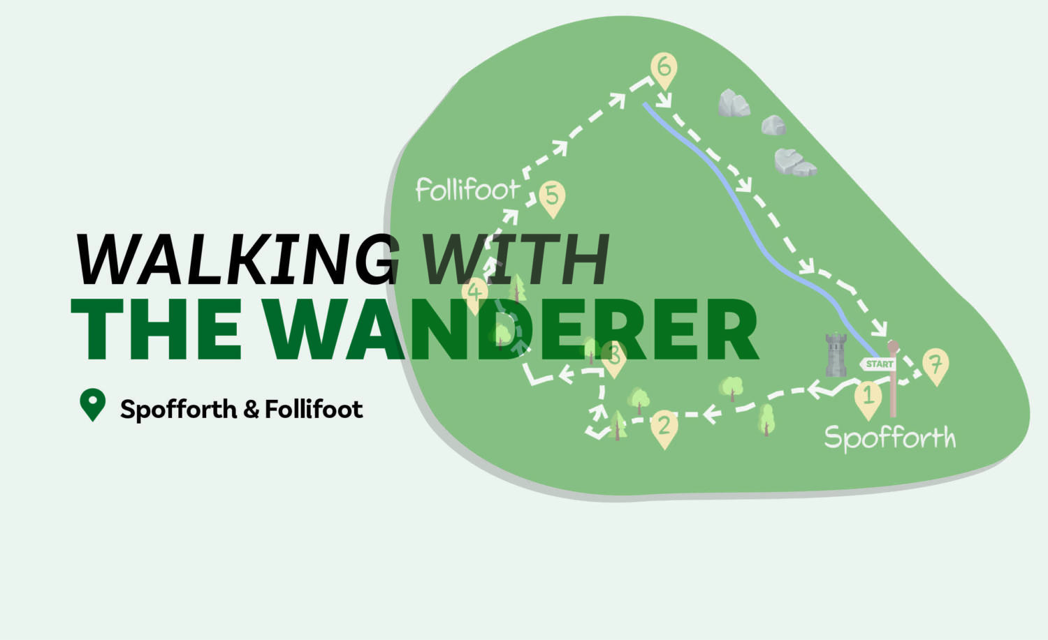
There’s lots of variety on this walk. Starting at Spofforth’s ruined castle, which can be freely accessed, dates from the 14th century. Leaving the village, the walk passes through attractive countryside where a range of wildlife can be seen, especially red kites. Follifoot has stone built houses, an imposing estate gatehouse and a pre-Norman cross. The pleasant walk alongside Crimple Beck provides further opportunities to spot wildlife. On the slopes to the left are the Spofforth Pinnacles, numerous gritstone rock outcrops of varying shapes and sizes.
Directions:
1/ With the Castle Inn behind you, go left along Castle St. Continue passing the convenience store until approaching a grassed area on the left beyond which are the castle ruins. Here turn left (Manor Garth) following the road as it becomes a gravel track then passes beneath the disused viaduct. Follow the track as it curves right under a hedge canopy. Remain on the obvious fenced and tree-lined track as it crosses the golf course. Keep going as the track passes a seat and goes downhill to run beside
a stream.
2/ At a bridge, cross the stream and go through the metal gate to fork half right up a slope following power lines. Where the ground levels, keep close to the wooded valley on the right passing through a gate. At the next gate go through and turn right on the track. In about 75-metres at a T-junction turn right. Follow the clear track over a bridge, continuing as it curves left uphill to a road.
3/ At the road turn left on the narrow but walkable left-hand verge. In about 400 metres, at a right bend and with buildings left, take the signed footpath across the road to the right crossing a stile into a field. Go across left of the trees. At a gate keep ahead between fences then descend steps to the abandoned railway line. Here cross to the left taking the right hand of two paths (not the grass permissive path) ascending
a slope.
4/ At the top, go right along the left edge of a field. Follow the path as it doglegs right then left into another field heading downhill. At the corner go right and follow a track over a stream. Where the track turns sharp left, go through a gap by a gate and continue ahead down a residential road.
5/ Turn left on Follifoot’s Main Street passing the Harewood Arms to reach a T-junction. Turn right, soon with the church left, then staying with the road as it goes downhill. Continue to the bridge over the stream. Immediately over this take the signed footpath on the right.
6/ The route now keeps close to the stream for well over a mile. At times the path is on the stream bank while at others it is ten or so metres to the left. Eventually, it reaches a metal footbridge. It is possible to cross this and return to Spofforth but the recommended route is to stay with the stream keeping close by it under trees for a further 500 metres to reach the main road.
7/ Here cross the road and turn right over the bridge. Just beyond the church turn right (Church Lane). Follow this as it bends left keeping ahead at a small green to a T junction. Either turn left towards the Castle Inn or right if beginning the walk from Follifoot or having parked near the castle.
Disclaimer
Walks are undertaken at your own risk. Due care must be taken in following the walk, particularly after poor weather. Whilst every care is taken in compiling the description changes may have occurred since compilation. Neither the walk author nor Your Local Link can accept any responsibility for errors or omissions.


Add a comment