GETTING THERE
Start from Pocklington bus station.
Pocklington is 15 miles from York accessed via the A1079 Hull Road. There’s ample parking in the town although the central streets have parking limited to two hours. Some limited roadside parking may be available on Kilnwick Road near the point the walk leaves and re-enters the town. Pocklington is accessible by frequent bus taking 45-50 minutes: bus 45/46 runs from York Station Road to Pocklington every hour while bus X46/X47 runs hourly from the Railway Station.
REFRESHMENTS
En-route there’s the Gait Inn and delightful Ramblers’ Rest tea room (closed Tue. and Wed.) both in Millington main street. Another option nearer the finish is the World Peace Café in the grounds of the Madhyamaka Buddhist Centre.
WHAT TO SEE
Pocklington has a range of independent shops in the Market Place and surrounding streets. All Saints Church, known locally as the Cathedral of the Wolds, is a grade one listed building dating from the twelfth to fifteenth centuries. Millington is a quiet farming village. It also has a grade one listed church, St Margaret’s, notable features of which include a twelfth century nave and Norman doorway. The Madhyamaka Buddhist Centre occupies the buildings and grounds of Kilnwick Percy Hall. Much of the house has been demolished but the grand entrance remains.
ONE.
From the bus station go right at the mini roundabout into Railway Street. Go over the zebra crossing at the end into Market Place (church to the left). Continue down Market Place passing the Coop to the left but just beyond The Feathers go right down Union Street. Where Union Street meets a road coming in from the left continue ahead (grassy area and beck on the left at first). About 125 metres along the road look out for Target Lane on the left highlighted by a footpath trail sign opposite.
TWO.
Turn left following the clear path initially with a grassy area to left. Cross a road and continue uphill on a stony path eventually reaching a transmitter mast. Keep ahead here going to the left of the wire fenced area with views down to the left. Follow the path into the wood going left at a fork to arrive at the edge of a golf course on the right. For the next 400 metres the route roughly follows the edge of the golf course on a path dipping in and out of the trees. When a car wide track is met turn left down it as indicated by the footpath sign. Keep on the track as it twists downhill passing an intensive unit on the right to reach a road
THREE.
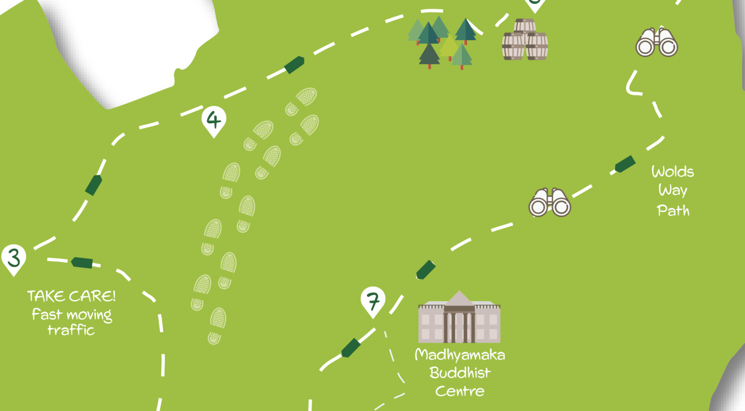
Turn right on the road watching out for fast moving traffic. After about 500 metres, where the road bends slightly right, go over a stile on the right to follow a signed footpath diagonally across pasture to a bridge over a beck. Follow the fenced path on the other side, then go through a gate with a fence to the right to continue to another gate leading to a driveway. Go right down the drive but in 75 metres look out for a footpath sign on the left pointing up a muddy bank.
FOUR.
At the top of the bank follow the field edge to the right then go left in the corner to keep the trees to the right. The route now continues along the edge of this and the next field, keeping the open ground to the left and trees/shrubs to the right. Eventually the trees/shrubs end by a metal gate where you go ahead on an obvious car wide track. Where the track joins a tarmac road go right. Follow the road towards Millington turning right at a junction by the village sign (to visit the church keep ahead).
FIVE.
Just after the street goes left and starts to go uphill go right taking a signed footpath heading downhill on a track. Go through a gate and with a house to the left take the path ahead (indicated by a very large ornamental arrow!) going down a fenced boardwalk into the valley bottom. Cross the beck and continue, at first on the boardwalk but soon climbing steeply up the shoulder of the hill aiming to the right of a prominent gate/fence ahead. At the fence do not cross but go slightly right uphill keeping it to the left. The route now continues with a fence on the left climbing uphill. After a kissing gate the fence ends at a redundant stile where you go straight on aiming toward the prominent signpost ahead marking a footpath junction.
SIX.
At the footpath junction turn right onto the Wolds Way. Follow the obvious path with a hedge/fence and views down to Millington on the right. After about 600 metres at the end of the field follow the Wolds Way sharp left for 100 metres before turning right, as indicated by a prominent sign, across a large open field. At the corner of the wood turn right alongside it, still following the Wolds Way. Keep the woodland to the left and continue beginning to go downhill with an open field to the right. Where the wood ends keep ahead to arrive at a narrow road on a right hand bend. Go straight ahead here on the road leaving the Wolds Way (which turns left as signed). Continue down the quiet road soon with farm buildings off to the left.
SEVEN.
After about 400 metres at the top of a drive to the left marked by a prominent parish noticeboard there’s a choice of routes. Option one, for the quickest return to Pocklington is to continue ahead on the road for a further 500 metres following it as it takes a series of gradual bends to the left until a footpath sign is encountered on the right, pointing the way across the golf course (continue at Point 8 (below). For a more interesting option through the grounds of the Madhyamaka Buddhist Centre see directions 7a (below).
SEVEN A.
To visit the Buddhist Centre go down the drive marked by the noticeboard. Pass Madhyamaka signs continuing ahead with the walled garden off to the left. Soon a white building appears and you come to a courtyard area at the far left corner of which is the World Peace Café. Exit the courtyard to the right keeping the buildings of the main hall to the left to arrive in front of the hall’s impressive entrance. Here go across the grass away from the hall to a metal gate beyond which steps give access to the parkland. It’s possible to walk across the park to the lake but an easier route is to veer right to pass besides a wooded area at the edge of which a stile gives access to the main drive bordered by metal fencing. Follow the drive away from the hall to the road. At the road turn right and in about 125 metres come to a prominent footpath sign on the left.
EIGHT.
Both routes now merge and head across the golf course. The path isn’t visible underfoot but is well marked by signs. If in doubt keep straight aiming for the right-hand edge of trees visible ahead. On reaching the trees keep them to the left soon following an attractive path with a line of trees to its right and wide views to the left. Where the path meets a junction continue ahead (left) going downhill on steps between gardens. On reaching a road cross it and continue down to reach another road. Here turn right but in 50 metres go left down another road. Follow this to the left to take an alleyway on the right (between nos. 14 & 15). At the next road turn left to arrive at the main (Kilnwick) road. Follow this right passing Target Lane to retrace your steps to the bus station via the Market Place.
DISCLAIMER: Walks are undertaken at your own risk. Due care must be taken in following the walk, particularly after poor weather. Whilst every care is taken in compiling the description changes may have occurred since publication. Neither the walk author nor Your Local Link can accept any responsibility for errors or omissions.


Add a comment