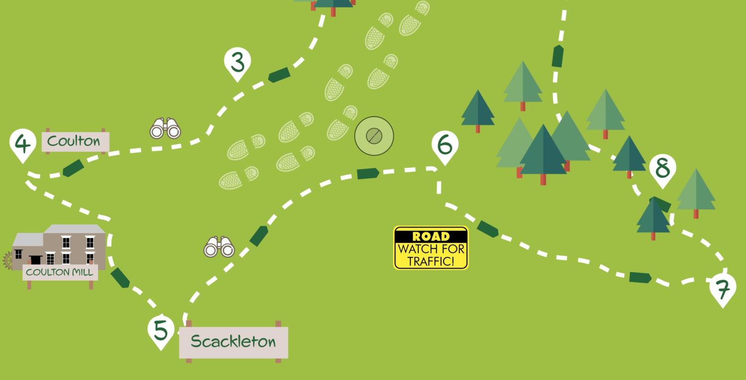
This walk in the Howardian Hills explores the undulating countryside to the south and west of Hovingham. The walk, which goes through farmland, woodland and parkland, includes several climbs, especially on the quiet road between Coulton and Scackleton. There’s also a very short stretch alongside a fast road at Point 6 in the directions where care should be taken. Apart from this, the route is straightforward and well signed, except after Point 3 in the directions where paths are indistinct and can be overgrown. The walk is about seven and a half miles long.
Getting there
The recommended starting point is Park Street in Hovingham where there’s usually plenty of roadside parking. It’s also possible to start in Scackleton but roadside parking is limited. Hovingham is 18 miles north of York approached via Strensall and Sheriff Hutton. Public transport to Hovingham is difficult. The only feasible route is to travel to Malton by bus or train and then take bus 194 which runs five times a day to the village (no Sunday service).
Refreshments
Both The Worsley Arms Hotel and Hovingham Inn (open Thu-Sun.) have lunch menus. The Hovingham Bakery & Rolling Pin Café is open Wed. to Sun. On Park Street, The Park at Hovingham hair salon doubles as a café and is open Tues-Sat.
What to see
This walk takes you through a wide array of countryside with plenty of woodland and attractive streamside sections. Good views can be had at several points over the Vale of Pickering and towards the North York Moors. Hovingham is an attractive stone-built estate village. The standout feature is the Palladian style Hovingham Hall with its unusual stable block entrance from the village. Further views of the house, normally open for a limited period in June, can be obtained from the path through the parkland. You’ll see Coulton Mill on a quiet roadside section, it’s part of a restoration project and developing cider making enterprise.
Directions
1. Starting outside The Park café and hair salon on Park Street go across the green opposite and head down the pavement of Main Street passing the Hovingham Inn and Stores. At Hovingham Bakery off the main road to the left take the adjacent footbridge and go left down Brook Street. In 100 metres go right on a tarmacked bridleway. In about 100 metres, where the bridleway turns left, go over a stile on the left just before the bend. Follow the path along the edge of the field, then cross a stile and track to continue with trees to the left. At the end of the trees, go over the footbridge and continue ahead (not left) along a line of trees between fields. At the kissing gate, turn left before passing through a farm gate.
2. With an ornate bridge visible ahead turn right and head through the grass pasture between the trees and the stream. Eventually, a stile will appear next to a white gate. Go over the stile, cross the road and take the signed footpath opposite through a gate into woods. At the end of the trees go through a kissing gate and continue with a fence and stream to the left. Keep with the stream on the edge of several fields to arrive at a kissing gate and track.
3. Take the track left but after 15 metres head right through a kissing gate into a field heading slightly left but keeping below house and garden. After a gate follow the path through an overgrown area with a pond to the right. Go through a metal gate into a field and follow the path through tall grass keeping near a fence on the right.
At the narrow end of the field go through a gate and over the bridge to head up a slope towards a gate in the fence line ahead. Pass through the gate and head uphill aiming for a telegraph pole. Before the pole, at a right angle in the hedge, go over a stile and continue with the hedge on the left. Where the hedge ends keep ahead on the track between crops. At grass field follow the track right but soon veer diagonally left across the grass to the left corner and exit onto the road at the edge of Coulton by a kissing gate.
4. Turn left on the road. This is followed for nearly a mile, at first steeply downhill passing Coulton Mill at the bottom and then steeply uphill to the edge of Scackleton.
5. Just after the Scackleton sign, take a sharp left down a tarmac lane. Continue on this No Through Route, going downhill and passing Newstead Farm, until the tarmac turns sharp left. Head straight down the bridleway signed Potticar Bank. At the corner of the field take the obvious grassy path uphill with a fence to the right. You’ll then reach a road.
6. Turn right on the road and go along it for 150 metres to take the signed public bridleway on the left. You’ll pass a farm on the right. Ignore a footpath to the left. After a line of trees on the left, the bridleway track approaches a farm. Here, leave the track going to the left of barns (as signed) on a grassy path.
7. Arriving at a gate: don’t go through it but take the path before on the left, signed Hovingham. Follow this between a field and a stream. Continue into the woods with a field on the left. At a gate follow the sign and go right over a ditch towards a gate to the left of a large oak tree.
8. Go through the gate into the wood heading uphill. At a junction go right on a track as indicated by a blue arrow on a low post. At a cross-track, continue ahead uphill. Ignore a path coming in from the left and in 20 metres keep ahead at crossing track. Soon leave the wood on a clear track heading across fields. Follow this with the roofs of Hovingham eventually coming into view to the road. Turn right then cross the road to take a tarmac footpath alongside the small green to join the main road as it turns sharp right. Continue on the main road, ‘High Street’, for a short distance to Park Street on the left.
DISCLAIMER: Walks are undertaken at your own risk. Due care must be taken in following the walk, particularly after poor weather. Whilst every care is taken in compiling the description changes may have occurred since publication. Neither the walk author nor Your Local Link can accept any responsibility for errors or omissions.


Linda Nelson
24 Aug 2020 at 09:16How many miles long is the whole route please?
Krystal Starkey
25 Aug 2020 at 09:02About seven and a half miles 🙂
Add a comment