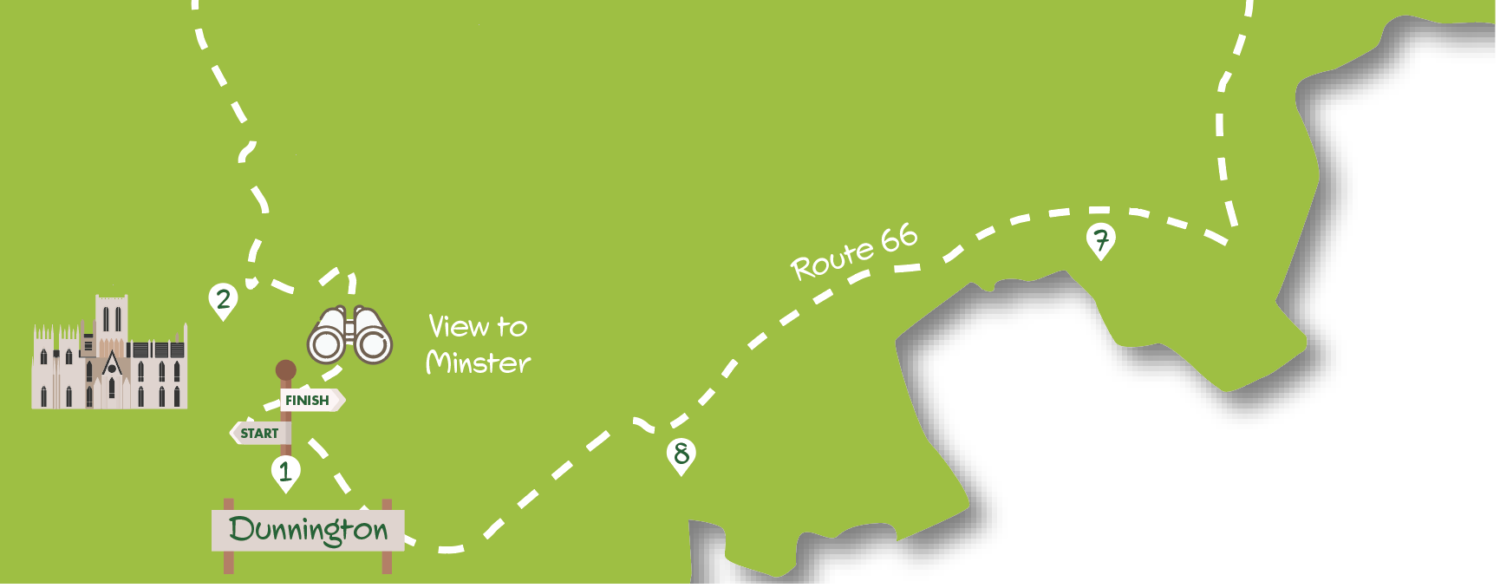
Starting from the old cross in Dunnington this route heads across fields to follow a quiet lane into Warthill with its church, pub (currently closed) and pond. Heading across a few more fields it passes the well-known Balloon Tree Farmshop & Café, to pick up the Route 66 cycle track. Heading down a tree-lined lane and then across farmland, this provides an easily followed and stile-free stroll back to Dunnington. The full route is about seven miles, but can be roughly halved by finishing at Gate Helmsley (or the Balloon Tree) and returning to Dunnington on bus no. 10. Apart from the section across fields near the beginning, this is a remarkably mud-free route making use of quiet lanes and the generally well-surfaced cycle track.
Getting there
Start the walk from the centre of Dunnington by the cross at the junction of York Street, Common Road and Church Street. Dunnington is just over four miles from central York. From the Grimston Bar interchange take the Hull Road (A1079) soon turning left onto York Road, which leads to York Street, where there should be adequate street parking. Bus no. 10 runs every 30 minutes from Piccadilly Mon-Sat daytime (less frequent on Sunday). East Yorkshire routes 45 and 46 also serve the village. Alight at the Greyhound stop in York Street.
Refreshments
Dunnington has a pub, the Cross Keys, the Old Butcher’s Shop Café (closed Monday) and Pattacakes bakery (closed Sunday). The Duke of York pub and The Balloon Tree café (open every day) both in Gate Helmsley provide opportunities for halfway point refreshment.
What to see
Despite being engulfed by suburban development, Dunnington has a range of interesting buildings in the streets radiating from the cross. The route out of the village, and again approaching Gate Helmsley, ascends modest hills offering good views, the former back to York and the Minster, the latter towards the Wolds. After passing the little known Brockfield Hall (private) the route comes to Warthill, an attractive village with an unusual nineteenth century Gothic church. The return on Route 66 follows Scoreby Lane, lined by young trees, before approaching Dunnington where thick hedges and adjacent woodland provide a good habitat for a range of wildlife.
1. Facing towards the cross on York Street in Dunnington go left uphill along Church Street. Follow the street as it bends left and right passing the church to Eastfield Lane on the right. Go down this lane with houses on the right and the cemetery on the left. After about 300 metres climb a stile on the left to follow the footpath, heading towards a telegraph pole, across the field. At the far side climb a further stile and turn left on the tarmac of the old road, now a layby, to reach the main road by metal gates. Cross with care and walk left a short distance along the verge to a track.
2. Take the track with a hedge to the right but in about 150 metres turn left at a footpath sign heading toward the end of a hedge visible across the field. At the hedge end turn right for a short distance to a telegraph pole, but then head left along the field beyond with a hedge and ditch to the right. At the end of the field cross the footbridge and continue with a hedge still on your right to emerge onto a car wide track. Turn right here to the road ahead. Turn left on the road (take care – some fast-moving traffic) for about 400 metres until a smaller road on the right signed ‘Warthill’.
3. The route now follows this pleasant minor road, Rudcarr Lane, all the way to Warthill. Approaching the village there’s a double bend and bridge over a ditch, after which houses start on the left and the road arrives at T-junction. Go left here following the main road around a bend to the pond.
4. Turn right by the pond passing the Agar Arms pub (currently closed) to take the left fork down a track signed as a public footpath. Follow this pleasant track as it curves towards a house ahead in the trees. At the house keep the wall/outbuildings to the right to emerge into fields. Go ahead on a grassy strip, then bend right with a hedge on the left to arrive at a tarmac lane on the edge of Gate Helmsley.
5. Go left on the lane (the Duke of York pub is just to the right), which runs parallel to the main road and passes the church, to a T-junction.
Turn right here quickly coming to the main road. Turn left on the main road using the pavement to pass the Balloon Tree Farmshop and café. About 200 metres beyond this cross the road with care to take the minor road on the right signed Scoreby and Route 66.
6. The route now continues down this lane, tree-lined at first, passing several houses and farms; then becoming a bridleway but still part of Route 66. After nearly two kilometres, take a tarmac track that branches off to the right (Route 66 sign) towards buildings.
7. Where the tarmac ends, go to the side of the buildings as signed to follow the obvious track across fields. Ignore a bridleway to the right at a bend continuing on the well-used cycle route soon with woodland to the left. At a crossing track go through the gate ahead eventually passing the buildings of Hagg Farm.
8. Continue on the obvious track curving right and left. Soon the track becomes a tarmac road with the houses of Dunnington to the right. On reaching the playing field on the left, bear right across the grass to pick up a tarmac footway by the houses. This merges into Common Lane, coming in from the left, which you follow right back to the cross in the centre of the village.
DISCLAIMER: Walks are undertaken at your own risk. Due care must be taken in following the walk, particularly after poor weather. Whilst every care is taken in compiling the description changes may have occurred since publication. Neither the walk author nor Your Local Link can accept any responsibility for errors or omissions.


Add a comment