Between Harrogate and Ripon
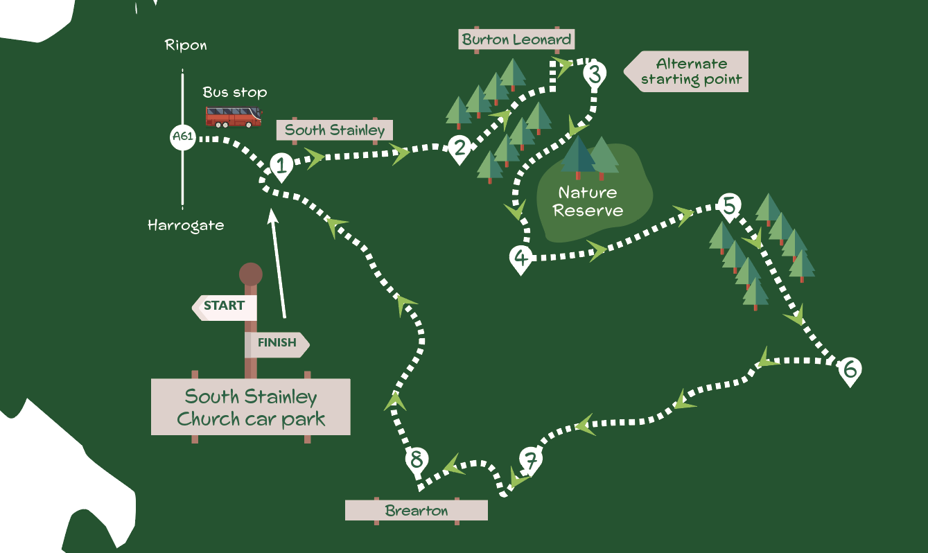
This walk traverses the undulating countryside between Harrogate and Ripon, much of it managed by the Mountgarret Estate. Mainly crossing farmland with a few stretches of woodland, it visits Burton Leonard, Brearton and a Yorkshire Wildlife Trust reserve.
Getting there
The walk can be started from South Stainley (recommended), Burton Leonard, or Brearton. South Stainley is 23 miles from York via the A59, B6165 and A61. Turn off the latter road at the pub and go down the narrow lane to find a small parking area by the church (donation requested). Public transport to South Stainley from York is by train to Harrogate then the frequent no.36 bus to The Inn, South Stainley. Another public transport option is the infrequent no.22 bus from York rail station to Burton Leonard (this service does not operate on a Sunday).
Is this walk for me?
The walk is fairly long with a few ups and downs, but no steep gradients. There are a few stiles to cross and several fields where grazing cattle or horses may be encountered. Much of the walk is on hard surfaces but there are several potentially muddy stretches. Most of the route is easy to follow with good signage. However, there are several points where care is needed to stay on track – see underlined sections in the directions.
What to see
The main attraction is the traditional and unspoilt countryside through which the walk passes. Burton Leonard with its green and array of different houses is one of the area’s most attractive villages. Burton Leonard Lime Quarries nature reserve has a mix of habitats including limestone grassland with the locally rare burnet rose and autumn gentian.
Refreshments
As well as The Inn near the start, there’s the Royal Oak in Burton Leonard (closed Monday and Tuesday) and The Malt Shovel at Brearton. The shop in Burton Leonard offers takeaway sandwiches and drinks (closed Saturday from 1pm and on Sunday).
Directions
1. From the parking area, take the path running alongside the churchyard wall (if coming from the bus stop turn left immediately beyond the church). Go over the stile into the next field keeping near the left edge and continue through the hedge gap into further field heading towards the wood ahead. Cross the stile and continue with the wood on your right. At another stile go right of the hedge to reach the track. Go left on the track. Now continue on the track initially with the hedge on the left, then through the dogleg, after which the hedge is to the right.
2. Soon after the track bends right at the ‘No Public Access’ sign on right, go left off-track up to the right edge of the field. After about 150 metres, at the three-way sign, go right up the steps into the wood. Follow a clear path uphill through the trees and keep the hedge left with the field right to meet the narrow road by houses. Turn left and follow the road into Burton Leonard. Turn right at the green, heading to the post office.
3. Turn right (signed Copgrove/Knaresborough) with the Royal Oak pub on the right. Continue on the road beyond the houses for 100 metres but where the road bends left go right on the tarmac lane. Ignore the right turn by the triangular green keeping ahead. Where the tarmac ends, head off the track on the parallel path into the nature reserve. Remain on the narrow path through the trees and the gate on your left. Stay with the path downhill, turning right at the back of the house to the gate giving access back onto the track. Turn left to the bridge beside the ford and continue ahead up the concrete track.
4. At the T junction, turn left. Now continue on an obvious track passing through the gates and pasture, then between the hedges before eventually reaching a tarmac lane with the stream on the left.
5. Turn right on the tarmac. Where the tarmac lane goes sharp right keep ahead on a signed bridleway. Continue into the woodland on a narrower path. Keep on the path downhill under the power lines.
6. At the junction where the wood ends, turn right through the gate into a long grassy field. Initially keep close to the hedge on the left then follow the direction of the power lines. Nearing the field end, go slightly left to a gap between the hedge and wooden fence to join the enclosed rough track. Continue on track which soon becomes a hedged tarmac lane. Remain with this for over a kilometre until the track joins from the right. Here, go left over stile opposite and walk diagonally across the field aiming to cross the stile near the buildings.
7. Turn left and follow the road right into Brearton, walking down the village street. Opposite the pub, take the narrow lane right (Lilly Gate Lane). Where this bends sharp right go left over a stile to walk down the left edge of the field. At the corner, climb the stile to find a further stile a few metres on the left beyond the hedge corner. Walk along the right edge of the next field but nearing the end, veer left to the stile 30 metres to the left of the corner. Go ahead (right of tree), then keep in the same direction walking alongside the hedge left to reach the gate. Turn right.
8. In 150 metres, where the road bends sharp left, turn right onto the concrete track (bridleway sign). Ignore the left turn after 400 metres curving uphill with the wood on the right. Keep left at the next junction continuing to follow the lane as it bends left downhill. Eventually, the lane crosses the bridge and runs close to the stream, reaching the edge of South Stainley and the parking area (if returning to the bus stop remain on the lane to the main road; if starting from Burton Leonard turn right beside the churchyard wall to continue.)


Add a comment