Barton-le-Willows, Crambe and the Derwent
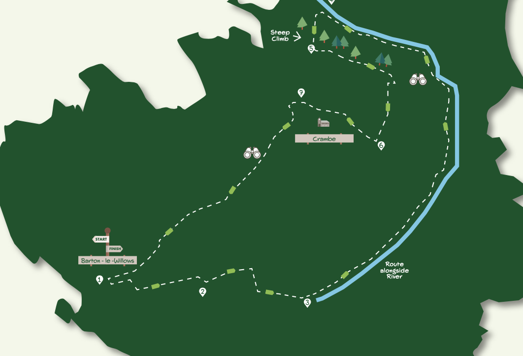
The highlight of this walk is a long stretch beside the River Derwent. It also provides an opportunity to visit Kirkham Priory and Crambe, one of York’s most tucked-away villages.
Directions: 7.5 miles Time: 3hr 15 mins
Getting There
The recommended starting point is the Barton-le-Willows crossroads. On-street parking is available in the village, and it is also possible to start from Kirkham Bridge, but parking spaces are limited. Barton-le-Willows is 11 miles from York via the A64 turning off at Steelmoor Lane. There is no direct public transport to either Barton-le-Willows or Kirkham. The best option is a Coastliner bus to Whitwell-on-the-Hill which is about a 20-minute walk from Kirkham Bridge (point four of directions).
Is this walk for me?
This is a generally easy route but there are two climbs, a few areas with encroaching vegetation, several stiles, and a narrow footbridge. Muddy patches may be encountered near the river – this section will be impassable when water levels are high. The path across the fields from Barton-le-Willows requires careful navigation as the route may not be clear on the ground.
What to see
The tranquil and unspoilt stretch of the River Derwent between Howsham and Kirkham offers one of the best riverside walks in the York area. Historic Howsham Hall and the trees of Howsham Wood are visible across the water.
At Kirkham, there’s the bridge, weir and ruined priory (entry fee applies). Tiny Crambe, has several interesting buildings. St Michael’s Church has a restored eighteenth-century organ and Norman font. Good views over the Vale of York and Wolds are available above the village.
Refreshments
The Stone Trough Inn, 500 metres over Kirkham Bridge, is open daily. The Kirkham Priory ticket office offers hot drinks and snacks.
- Starting from the crossroads in Barton-le-Willows, take the road signed ‘Howsham’ and ‘Leavening’ following it as it bends left. At the junction go right (signed ‘Howsham’) but in about 50 metres, look for an inconspicuous footpath marker left by a hedge gap. Take the path to the field corner on the right, then head left down the field. Keep the hedge to the right, kinking left and right, to eventually arrive at the field’s far-right corner. Go into the young trees, soon reaching a T-junction. Turn right with the stream on the left. In about 100 metres, go left over a narrow bridge part embedded in the tree trunks.
- Walk ahead across the field aiming for a gap halfway along the hedge on the other side. Once through the gap, continue straight across the next field to a further hedge gap. Turn immediately right to a wooden fence in the corner of the field. Now walk ahead on the narrow path between fence and hedgerow. At the field end, go through the gate and turn left with a hedge on the left, and a fence on the right. Cross the track in front of the farm and continue on an enclosed path downhill to the road. Cross and go through the gate opposite to walk alongside the hedge to the gate, giving access to the riverside path.
- Turn left and walk alongside the river which continues for nearly three miles, passing through gates and crossing ditches and boardwalks. Nearing Kirkham, the path enters woodland. Keep close to the river, climbing slightly as the path approaches the weir. Exit the wood to walk over the grass to a gate adjacent to the road bridge.
- Turn left and go over the level crossing (to visit Kirkham Priory and Stone Trough Inn, go right over the bridge). About 30 metres beyond the railway, take the signed path left into the woodland which soon swings right and climbs steeply through the trees. Follow the path out of the wood to the road.
- Turn left, but in 50 metres take a signed path to the left through a metal gate. Keep with the path as it enters the right edge of the woodland, staying above the steep bank to the left. After the obvious path crosses a wider patch of woodland, go through a metal gate and turn right in the field alongside the wood to the field corner. Here, turn left with a hedge on your right. Continue across the grass heading downhill with a farm on the left, meeting a farm access track at the bend. Go ahead (right), following the access track to the road.
- Turn right on the road and continue until the road bends right. Here, take the signed path on the left (footbridge) leading to Crambe churchyard. Keep left of the church to reach the road through the wooden gate.
- Go ahead on the road (signed ‘Unsuitable for Motors’), following it through a double bend. Keep right at ‘Badgers Brook’ on the earth track. Go through the metal gate and bend left with the track behind the house. Then, swing right uphill with a gulley on the left to another metal gate in the left corner. Go through the gate and continue on the track.
- At the brow of the hill continue ahead, ignoring the track on the right. Descend with the track, ignoring footpaths leading to the left. Keep ahead where the track joins from the left. Go over the level crossing, after which, the track becomes tarmac. Cross the brick bridge staying with the tarmac as it kinks left and right. Approaching the houses, keep right to walk down the village street to the crossroads starting point.


Add a comment