
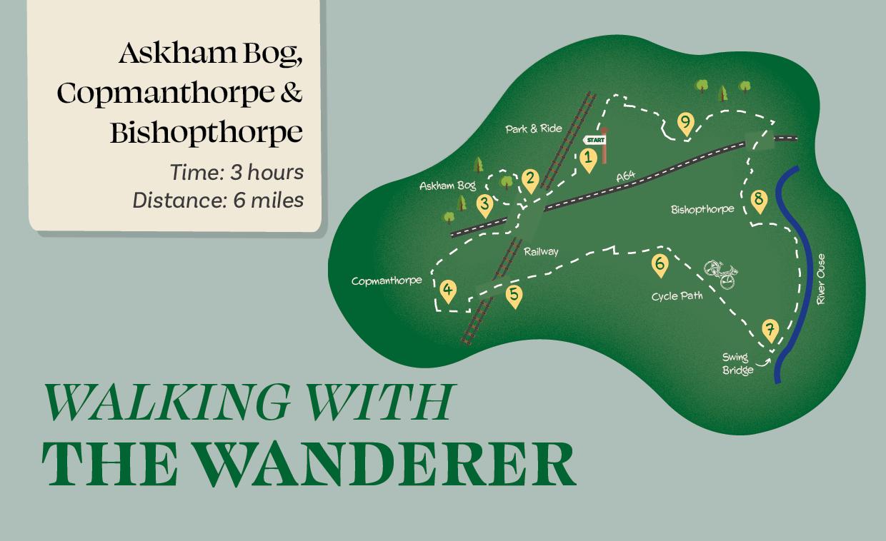
Time: 3 hours
Distance: 6 miles
This walk around the southern fringes of the city includes a nationally significant nature reserve, two suburban villages, a stretch of the National Cycle Network, and a length of riverside.
Is This Walk For Me?
This is an easy and almost entirely flat walk. Most of the route is on hard surfaces. However, the footpath linking Copmanthorpe and Bishopthorpe can be muddy in winter, and the riverside section may be impassable when the river is very high. There are no stiles. All the stretches alongside roads are on pavements. The crossing of the busy railway (Direction Point 5) must be made quickly and only when the green light indicates it is safe to do so.
Getting There
The walk could be started from Askham Bar Park & Ride, Copmanthorpe or Bishopthorpe. The first option is convenient from much of the city. If using public transport, bus no. 3 runs frequently every day from Rougier Street and the railway station. Copmanthorpe is served by buses 13 and Coastliner 840 and 843. Bishopthorpe is served by bus 11 (although not on Sundays).
Refreshments
Copmanthorpe and Bishopthorpe both have pubs and cafes – But First café in Bishopthorpe is highly recommended. On the riverside before Bishopthorpe, there is Bosun’s restaurant and café bar. Check websites to confirm opening times.
Download Your Route Map
Directions
1/ Starting from the park and ride site, exit through the vehicle entrance, going right on the tarmac footway to walk alongside the road leading from the A64. Just after the railway bridge, continue towards the far end of a parking area. If taking the detour into Askham Bog, go through a gate on the right. If omitting Askham Bog, continue from Direction Point 3.
2/ Follow the enclosed path, which turns sharply towards the nature reserve. Here, take the boardwalk going ahead at a boardwalk crossroads. Remain on the boardwalk for about 800 metres as it circuits part of the reserve. When back at the boardwalk crossroads, turn right to retrace your steps.
3/ At the end of the parking area, cross the road using the pedestrian lights. Follow the tarmac footway going under the A64 bridge. Just after this, beside a seat, take a footpath right, providing a route away from the roadside for a short distance until the edge of Copmanthorpe village. Continue on the road (Top Lane) until an easily missed footpath sign between houses on the left. Take this enclosed path, which runs between gardens, to emerge into a small grassy area (Low Green).
4/ Cross this to the left, going over the road to a signed footpath by green railings (for refreshment opportunities, go right passing the Co-op on the left). Follow the path, soon between a school and a sports ground, as it bends sharply left and right, before leading into a suburban road. After a short distance turn right, but very soon after the road just joined bends left, go right (Sawyers Crescent). Keep ahead with the railway line, turning left alongside it with houses to the left until you reach a footpath crossing.
5/ Cross the tracks, making sure only to proceed when the green light shows. Keep ahead following the footpath, with a ditch and hedge to the right. At a field end corner, go left for 30 metres, then right over a ditch to continue right of a hedge. At a further field corner, go right for 60 metres, crossing a ditch and following a path around a garden to reach a tarmac lane. Continue along this into houses. At the cycle track denoted by a blue signpost, turn right into a suburban road. Where this goes right, turn left (cycle route sign), passing under a bridge.
6/ Follow the cycle track for about 750 metres until you reach a bridge across a road. Immediately over this, go down the steps on the left and take the lower of two paths leading right, initially with a wooden fence at the left. Remain on the path as it goes left, by an enclosed area to the riverside.
7/ Continue close to the river, with moorings right on a field edge path. Ignore a car track left, remaining by the river now closer to the moorings. At a metal gate, keep ahead, soon joining tarmac to pass Bosun’s Restaurant. Just beyond this, where the tarmac goes left, keep ahead by the river on a footpath with railings to the left. Continue as the path leaves the river to join a dead-end road, leading to Bishopthorpe’s Main Street.
8/ For most refreshment opportunities, go ahead, but to continue the walk, turn right passing Bishopthorpe Palace. Remain with the road crossing the A64 bridge. Shortly after this, opposite the entrance to Middlethorpe Hall, take a signed cycle track left. Cross two arms of the racecourse, remaining on the tarmac with woodland to the right and fields to the left.
9/ Where a tarmac path leads off right marked ‘look both ways’, follow it, with playing fields at the left and a hedge at the right. At a grassy area, keep left of the playground, still on the tarmac track with houses to the right. Eventually, the track bends right to a road. Turn left and continue to the roundabout at the main road. Here, turn left to cross at the pedestrian lights, then head left on the treelined pavement to pass Dringhouses Cemetery. Just beyond this, take the signed pedestrian access into the park and ride site.
What To See
Askham Bog is one of the most ecologically diverse sites in Yorkshire. A small part of this Yorkshire Wildlife Trust nature reserve can be visited on a boardwalk (Direction Point 2). The riverside section provides opportunities to view waterside activities and wildlife. As well as being home to the Archbishop’s Palace, Bishopthorpe has a main street of attractive buildings. The route after the racecourse runs alongside the under-appreciated Knavesmire Wood, as well as a newer section of woodland.
Disclaimer
Walks are undertaken at your own risk. Due care must be taken in following the walk, particularly after poor weather. Whilst every care is taken in compiling the description, changes may have occurred since publication. Neither the walk author nor LocalLink can accept any responsibility for errors or omissions.


Chris
08 Nov 2025 at 17:59Just tried to do this walk today. We parked in bishopthorpe and started the walk from point 8. Unfortunately the railway walking crossing at point 5 is now closed.
Add a comment