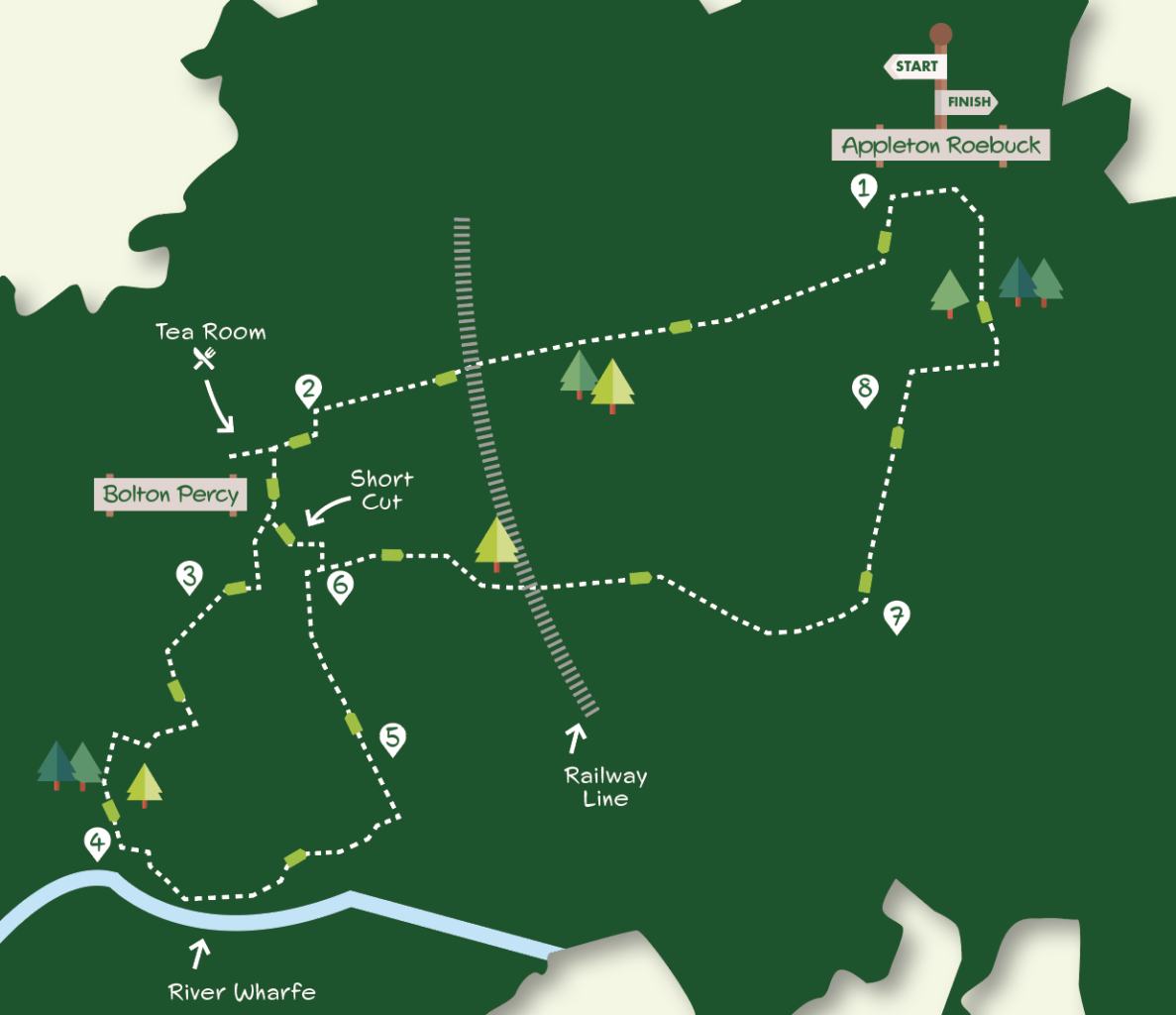
2¾ hours 6 miles (short walk 4 miles)
Appleton Roebuck and Bolton Percy are situated in an area of quiet countryside between the river Ouse and Wharfe, away from busy roads. The walk, which can be shortened by emitting a riverside section, visits both villages. Its main charm is the unspoilt countryside traversed with a mix of fields, hedged tracks and avenues and new woodland plantings.
Getting there
The recommended starting point is the Roebuck Inn on Appleton Roebuck Main Street. It is also possible to begin the walk in Bolton Percy. Roadside parking is available in both villages. Appleton Roebuck is eight miles from York travelling via Bishopthorpe (or the A64 and Bilbrough Top). Bus 21 runs infrequently from the Railway Station to both villages (not Sunday). The last return bus leaves Appleton Roebuck at 16.17.
Is this walk for me?
This is an easy route, flat except for bridge and bankside inclines. There are no stiles on the short route but a number on the longer route south of Bolton Percy. This part of the walk also requires careful navigation and maybe impassable when river levels are high.
What to see
Bolton Percy has several interesting buildings including the fifteenth century All Saints Church and the nearby half-timbered Gatehouse. The graveyard opposite the church is a quiet retreat planted with flowers and shrubs. The riverside section south of the village has a range of flora. In May, large patches of pink-flowered Common Bistort can be seen.
Refreshments
The only option is the highly recommended Doylys Tea Room at Bolton Percy, open Wednesday to Saturday 10am to 3pm. Both pubs in Appleton Roebuck and the pub in Bolton Percy are currently closed.
Directions
1. Starting with the Roebuck Inn behind you, turn left on Main Street. Take the first turn left (Bond End), then in 200 metres turn right (Church Lane). Continue ahead where houses end on a wide grassy track between hedges. Stay on this, ignoring the footpath left after 750 metres, to go over the railway. Continue through a bike barrier after which the track becomes tarmacked and leads to a road.
2. Turn left towards Bolton Percy but in 80 metres go right. In a further 150 metres turn left signed 15th-century church (for Doylys Tea Room keep ahead). Pass church to right then keep right downslope with treed area to right. At the road junction, turn right. Before a private road sign, turn left on an earth track. (For the short walk turn left soon after the church then head immediately right down Pump Alley. At a bend keep ahead to go over stream staying with the path as it bends to a road. Turn left on the road but in 50 metres go right (ahead) and continue the walk (Direction Point 5 below).
3. In 50 metres, just beyond the house, go over a stile on right and walk towards the wooden fence visible in the field corner. Shortly before the fence, cross a stile in the hedge to left and go ahead on a rough, rubble patched, track with the hedge right. Just after the hedge kinks right, go through a gap (low post waymark) across the field to the hedge corner. Reaching this, continue with the hedge right towards the metal gate. Go over the adjacent stile and turn left alongside a hedge. Approaching a copse go through a double stile, quickly reaching a further stile, giving access to a riverside pasture. Go forward towards the nearest pylon following a faint path ahead to the bank.
4. Ascend the bank and turn left with the river right. Continue on the bank for 500 metres to a fence and stile. Do not cross but go down the bank to a stile by a metal gate. Go over this and then climb a further stile on the left in five metres. Head half right, crossing a concrete bridge over a ditch. Then veer right following a faint path with pylons to the right and hedge left towards the far end of the pasture and a waymarked gate. At the gate go left up the grass track but in a few metres go right (ignore the tempting metal gate left) with the hedge left. Cross concrete bridge and swing left on obvious track towards buildings and gate.
5. Go over a stile by a gate and continue on a hedged track which soon becomes a tarmac road. Continue into houses following the road round a right bend (short route joins here) but 50 metres beyond, where the road bends left, go right (ahead) down a road marked by a no through road sign.
6. Keep on the road through bends and over the railway. At Oak Lodge keep ahead through pillared gateway now on rougher, hedged, track. Approaching further gatehouse, go left through a metal gate on the drive.
7. Continue on a straight tarmac drive for 700 metres until a tarmac lane on right.
8. Turn right on the lane. Immediately after the lane crosses a stream and with houses ahead go left on the beaten path across grass. Follow this into trees to join a wider path continuing ahead (left) with the stream to left. Go left over the bridge and follow the track into Appleton Roebuck. Turn left at the small green to return to Main Street.
Disclaimer Walks are undertaken at your own risk. Due care must be taken in following the walk, particularly after poor weather. Whilst every care is taken in compiling the description changes may have occurred since publication. Neither the walk author nor Your LocalLink can accept any responsibility for errors or omissions.


Mr Summers
09 Apr 2023 at 16:20We stumbled upon this one morning and decided to try it later that day. A lovely long walk and most of all your directions were precise. Thank you.
Add a comment