AROUND AND ABOUT ALLERTHORPE COMMON
This is an easy walk, ideal for a short winter stroll. The first half traverses Allerthorpe Common, a mix of mainly coniferous woodland and more open areas managed by Forestry England. The woodland has a network of paths which can also be explored if you want to extend or vary the walk described below. After reaching the small village of Allerthorpe, the second half of the walk crosses quiet farmland. The entire route is on easily followed paths, most of which have good surfaces. Any muddy stretches are easily circumvented on side paths. Please note, after very heavy rain some sections of Allerthorpe Common can be subject to surface water flooding.
Distance: 5 miles
Time: 2 hours
Getting there
The easiest starting point is Forestry England’s car park on Common Lane. This is the second car park if approaching from the A1079. It is also possible to start the walk from Allerthorpe village where roadside parking is available. Allerthorpe is 15 miles from York just off the A1079. For the Common Lane car park turn right off the A1079 beyond Wilberfoss signed Sutton upon Derwent. Soon after the road enters woods, turn left into Common Lane. The car park is on the right after 500 metres. Unfortunately, there are no viable public transport options to either this or the Allerthorpe village start point.
Refreshments
The only option is The Plough at Allerthorpe open daily from midday except for Mondays.
What to see
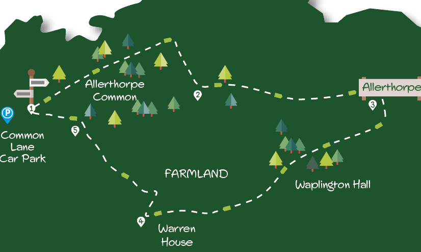
The main feature of the walk is the tranquil wood and heathland of Allerthorpe Common. Unenclosed common until the 1960s it was then blanketed with conifer trees, mainly Scots pine. Recently areas have been cleared creating a more diverse habitat. Many rare species inhabit the common. Part of the common, not directly passed on the walk, is a Yorkshire Wildlife Trust reserve. Nineteenth-century Waplington Hall, glimpsed at point three in the Directions, sits on the site of a lost medieval village. The well-drained flat and sandy farmland nearby is extensively used for lawn turf growing.
Directions
Starting from Forestry England’s Common Lane parking area, cross the road and go through the metal gate opposite. Take the wider main (centre) track between birch trees. Continue on this well-surfaced track ignoring all side tracks and paths off. Reach pylons after about 800 metres, then keep ahead for a further 500 metres. At this point, where the straight track ends and with a wooden hand gate in front, go sharp right on a lesser track with a fenced open area left and woodland right. Ignore side paths eventually following the track as it bends left to a wooden gate ahead.
Go through the gate and continue on the narrower path through birch woodland. Keep ahead striding over a narrow stream/ditch. When the path emerges from the trees keep ahead with a field on the left. After a bridge over a ditch ignore the track joining from the left to arrive at buildings on the right. Go through double metal gates and at the grass triangle take the tarmac road right to arrive at Allerthorpe immediately to the right of the Plough pub.
Keep right (ahead) following the road (not left up the main street) passing the village hall right. At the end of the houses, take the tarmac lane off to the right signed ‘Waplington’. Continue on the lane, keeping right at Lake Lodge on the now rougher track through trees, soon passing a large white house (Waplington Hall) left. Where the track splits, keep ahead following yellow waymarks. Continue under the pylons, after which the track swings right with buildings (Warren House) visible ahead.
Keep the buildings of Warren House to the left and at its gateway turn sharp right as directed (not ahead on tarmac drive) on a rough track. In about 150 metres by an elevated green tank turn sharp left (footpath sign to right) along the edge of the field with the hedge right. Now keep going with the hedge right along the edge of several more fields until the track approaches woodland ahead.
Here, where the track bends sharply left, go through the hand gate ahead into the wood. In a few metres, at a path T junction, turn left. Now continue ahead on the earth path skirting any muddy sections. If in doubt keep the mainly pine trees right and mainly birch trees left. Soon a field is visible on the left, then a metal gate. Through this are Common Lane and the car park starting point across the road.
DISCLAIMER: Walks are undertaken at your own risk. Due care must be taken in following the walk, particularly after poor weather. Whilst every care is taken in compiling the description changes may have occurred since publication. Neither the walk author nor Your Local Link can accept any responsibility for errors or omissions.


Add a comment