
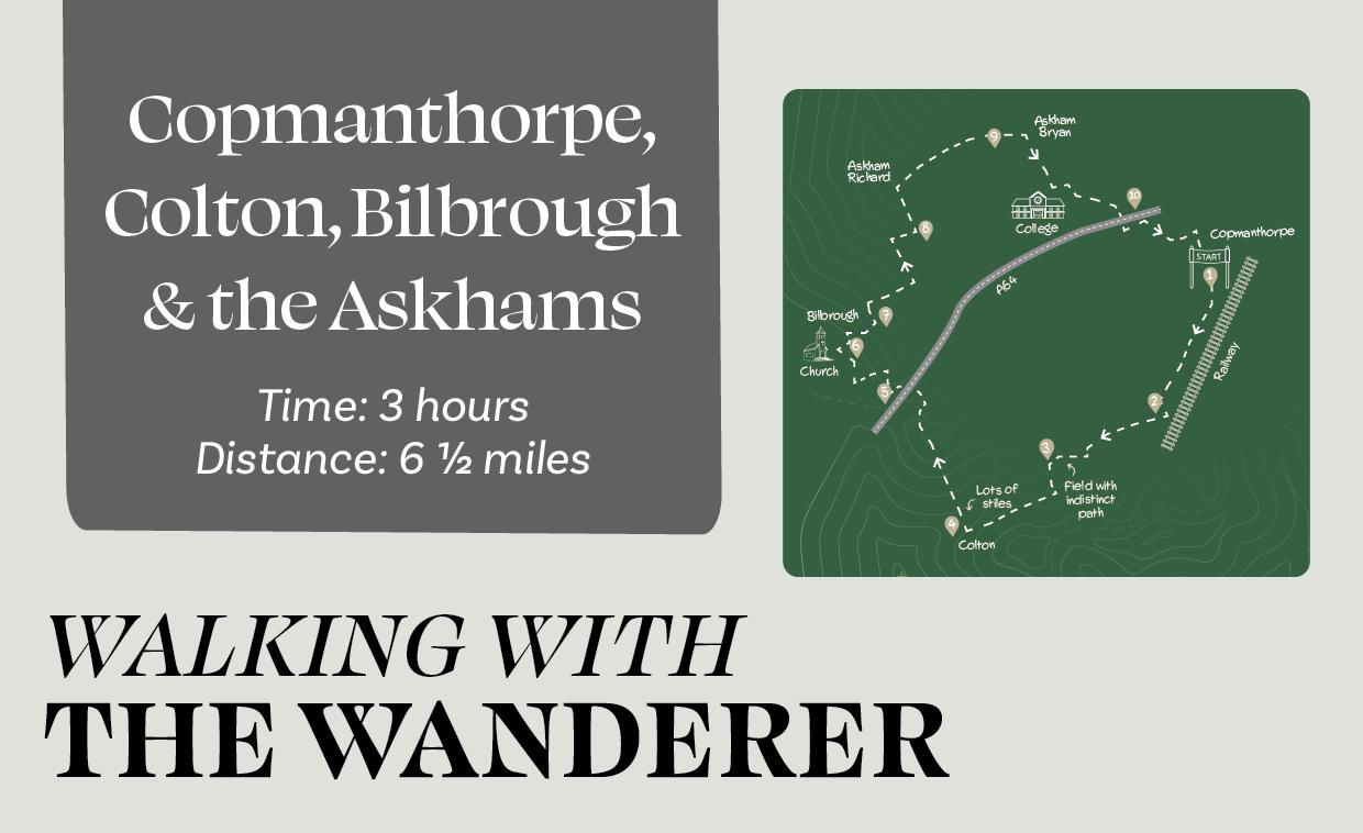
Time: 3hours 6½ miles
Traversing varied countryside, this route links no less than five villages. Apart from Copmanthorpe, all are relatively small and quiet, despite the proximity of the busy A64.
Is This Walk For Me?
Medium length with just minor slopes, this walk is generally easy. The A64 is crossed safely on bridges, however, there are stiles, some steps and plenty of mud in winter. Cattle may be grazing in fields after Colton. At Direction Point 2, route finding can be hampered by crops covering the footpath.
Getting There
The recommended starting point is the Royal Oak pub in Copmanthorpe, four miles from York via Tadcaster Road. There is roadside parking on Horseman Lane and nearby roads. It would also be possible to start the walk from any of the other villages. Regular Coastliner buses stop on the route, at Hallcroft Lane in Copmanthorpe. The less frequent no.13 service (not running on Sundays) runs to Main Street, just beyond the starting point. Both routes depart from Stonebow and the station.
Refreshments
There are two pubs, the Royal Oak in Copmanthorpe and the Nags Head in Askham Bryan, both open daily. There is also Little Acorns café in Copmanthorpe, open until 3.30pm (2pm on Saturdays, closed on Sundays), and The Grange Coffee Shop in Askham Richard (just off route, keep on road at the pond), open until mid-afternoon from Wednesday to Sunday.
Directions
1/ With the Royal Oak pub behind you, go left, soon passing the Methodist Church. Keep ahead at Station Road on Moor Lane. Just beyond the cemetery, take the signed path right between repurposed water containers, across a field to a hedge corner. Continue ahead with the hedge to your left. Where the hedge ends, cross the footbridge and walk towards the railway, heading slightly left of a prominent tree to a hedge gap.
2/ Turn right on the grassy hedged lane. Where this ends, continue ahead between crops towards a cluster of trees, soon walking beside a hedge to the right until you reach a footbridge. Over this, the path is often covered by crops. The right of way crosses directly over the large field to an entrance near a telegraph pole and a house. (At the time of walking, there was no clear path, but turning left at the field edge and then following the second tramlines right leads to the field exit).
3/ After crossing the field, turn left on the tarmac lane, which soon bends sharp right into Colton. Continue, passing the Fairfax Distillery. Just beyond the brick church, take the signed path right, at a stile between houses.
4/ Follow the clearly marked path over more stiles. Entering a larger field, cross its corner towards a prominent tree, continuing along the left edge. After another stile, cross a grass field, heading slightly right of the tallest tree. Go over a further stile. Keep ahead until you reach the last stile and a road. Turn right on the verge. At the junction, turn right (blue Bilbrough sign), crossing the A64 bridge.
5/ At the T junction beyond the bridge, turn right, but in 25 metres, cross the road and go through a hedge gap by a metal pole. Turn immediately right to the near field corner (if you miss the hedge gap reach the field corner at metal gates further along the road). Turn left with a hedge right. At a gap (small sign), cross into the next field, continuing in the same direction with the hedge to your left. At the field end, turn right. In 30 metres, go through the gap into a grass field. Follow the path near the right hedge, soon passing a pond to the left. Through a squeeze stile, pass Bilbrough church left to the village street.
6/ Turn right. In a short distance, by the telephone box, cross over to take the signed footpath between houses to a tarmac road. Turn right, remaining on the road to a T junction.
7/ Turn left. After the bend, take the signed bridleway left. At the brow of a hill, by a seat and beech trees, turn right (no sign) with a hedge to the left. Cross two stiles, continuing along field edges for 600 metres. Turn sharply left down steps, then continue through two fields with hedges at the right to a road. Turn right.
8/ At the next junction, go left (signed Askham Richard) on the verge into the village. Opposite the pond, look for a post box over to the right (beyond the closed pub and next to Old Joiners Cottage) and take the track to its left. Go through a kissing gate, then keep near the hedge at the left. Cross the planked ditch to go diagonally left across the wider field, to the far corner and a kissing gate. Cross the track, going ahead on the path opposite with a fence to the left. After double stiles, walk along a field edge, then a hedged track, to reach tarmac at a sharp bend.
9/ Go ahead into Askham Bryan village. Pass the Nags Head and take the first road right (Chapel Lane). Continue to a T junction and turn left. At the next T junction, take the signed path between wooden fences. Pass the double gates between houses/buildings until you reach the college entrance. Turn left, continuing on the road. Turn right to reach the roundabout.
10/ Keep to the roundabout’s right side, then go over the A64, after which, turn left into Manor Heath (Coastliner bus stop). Continue with houses to the left and fields to the right, until you reach a crossroads. Here, turn left into Hallcroft Lane. At the next junction (Horseman Lane), turn right (no. 13 bus stop in 30 metres) to return to the Royal Oak starting point.
What To See
Each of the villages has an interesting range of buildings. Askham Richard, with its green and duck pond, is almost the quintessential English village. The main historical feature is the Fairfax Tomb in Bilbrough Church. The countryside, especially around Bilbrough and beyond Askham Richard, is unspoilt with pockets of woodland and varied wildlife. In otherwise flat terrain, the small rises near Bilbrough give far-reaching views to York Minster and over the wider countryside.
Disclaimer
Walks are undertaken at your own risk. Due care must be taken in following the walk, particularly after poor weather. Whilst every care is taken in compiling the description, changes may have occurred since publication. Neither the walk author nor Your Local Link can accept any responsibility for errors or omissions.


Add a comment