
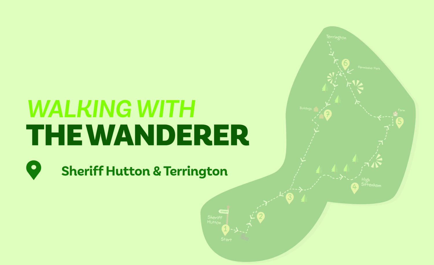
Time: 3½ hours Distance: 7 and 1/4 miles
This is a walk with several options. The recommended full route starts at Sheriff Hutton and continues to Terrington where there are refreshment opportunities. However, it is possible to shorten the walk by about a mile if the leg into Terrington is omitted. Another option is to start at Terrington and either do the full walk or leave out visiting Sheriff Hutton, an option that’ll shorten the route by about a mile and a half.
Is This Walk For Me
A longish walk, this route also has a few climbs, most are short but two are quite steep. Mainly over farmland — including through fields in which cattle and horses may be grazing— the walk has few stiles and is generally well waymarked.
Getting There
The recommended starting point is The Green in Sheriff Hutton, where roadside parking is available. Bus 81 provides a limited service to Sheriff Hutton (not Sundays). Alight at Main Street and walk ahead to The Green. If starting from Terrington park near the Village Store on Main Street. There is no viable public transport option to Terrington.
Refreshments
The Highwayman Inn at Sheriff Hutton is open daily except Monday. The café at Terrington Village Store is open every day (closes 4pm Sunday).
What To See
Sheriff Hutton has much of interest including the ancient church and remnants of a castle. Terrington is a quiet, unspoilt village set on a hill. In-between is a mix of farmland and woodland broken by several, mostly wooded, hills.
Download your FREE digital walking route map!
Directions
1/ From The Green in Sheriff Hutton continue ahead along the street (dead end sign). Where this divides, keep left (downslope). At Peckitt’s Close go ahead to a wooden gate. Through this, turn left on the fenced path to a stile. Cross and continue in the same direction over the field to a stile at the road.
2/ Follow the verge right for 40 metres, then cross and take a track on the left. In about 100 metres do not go through gates ahead but turn right beside other gates along the edge of a large field with a hedge right. Continue to cross a wooden bridge to arrive at the end of the field and a track.
3/ Go ahead over the ditch and walk straight across the field towards the left edge of the trees. Reaching these, go half-left up the bank as signed. Now continue with the steep treed bank to the left for about 400 metres. Nearing the wood’s corner you will reach a footpath junction. Here, turn half-right over the field to find a way into the wood. Follow the obvious path through the trees. On leaving these, continue passing an overgrown pond then keep right to reach the end of the dead-end road at High Sittenham.
4/ Keep ahead at the path junction, following the Centenary Way sign to pass to the right of houses. On reaching a gate follow the rough track over the grass. Where this splits, go left keeping near the wood edge to a further gate. After this, keep to the hedge to the right (ignore a tempting gate right though) downhill to cross a substantial bridge. Continue uphill with a hedge right. Where this ends, go right as signed through a metal gate with a hedge left. Soon reach another gate, after which turn left alongside a hedge. Continue ahead, merging onto a track coming in from the right.
5/ At farm buildings turn left on the track, which becomes tarmacked and heads uphill. Now remain on this quiet tarmac track for over a mile ignoring all paths off to the right and left to reach Terrington. On entering the village keep ahead at a crossroads then fork left to find the stores/tearoom. If not continuing to Terrington look for the permissive path sign as in Direction Point 6 below. To return from Terrington retrace your steps passing the cemetery to the right. Soon after, either take the signed Ebor Way path right across the horse pasture or continue for 100 metres to a permissive path.
6/ At the easily missed permissive path sign on the right (this will be on the left if not returning from Terrington) walk to the brow of the hill with a hedge right. Turn left, go through two gates then enter woodland. After a short distance turn right. Ignore a track heading downhill, instead taking the signed path just beyond it also going downhill but into the trees. This soon arrives at a wooden gate leading to a concrete track. Follow this right downhill. At the bottom keep right of the first house and left of the second to find a gate into a horse field (footpath sign).
7/ Go over the field to a small gate. Continue in the next field with a hedge left. At the field end turn left, but in about 100 metres turn right, crossing the deep ditch and going through a gate. Now walk ahead with a hedge left. Where this ends, keep in the same direction to go through a further gate and over a ditch. Remain ahead on the rough track with a ditch left. Eventually the track becomes partially hedged and leads to the outward route from Sheriff Hutton at Direction Point
3. to return to Sheriff Hutton go right retracing your steps through Direction Point 2 then 1. If returning to Terrington turn left over the bridge continuing from Direction Point 3.
Disclaimer Walks are undertaken at your own risk. Due care must be taken in following the walk, particularly after poor weather. Whilst every care is taken in compiling the description changes may have occurred since publication. Neither the walk author nor Your Local Link can accept any responsibility for errors or omissions.


Add a comment