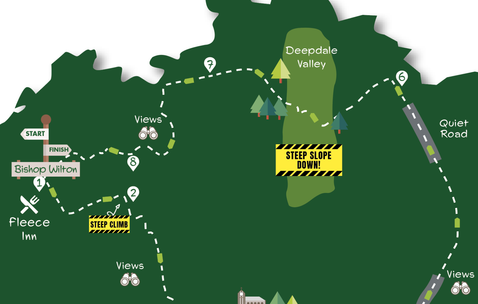
This is a walk of wide views and quiet valleys. After climbing high onto the Wolds from Bishop Wilton, where there are far-reaching vistas over the Vale of York, the walk arrives at the hamlet of Great Givendale with its picturesque church. The route then traverses typical Wolds country, dipping into a deep valley before returning to the top of the escarpment and dropping back down through hillside pastures to Bishop Wilton.
Distance: 8 miles, Time: 4 hours
Getting there
The recommended starting point is the crossroads in Bishop Wilton by the Fleece Inn. Bishop Wilton is 15 miles from York following the A166 and turning right at the bottom of Garrowby Hill. Bus 747 runs three times per day from York Railway Station to Bishop Wilton Mon.-Sat. stopping at the crossroads. The last return bus is currently at 14.18. It is also possible to start the walk in Great Givendale using roadside parking.
Is this a walk for me?
This is a fairly challenging walk. There are two climbs, one with steep sections and another with steps. There is also a very steep descent. Path conditions are generally good although there are boggy areas on the ascent and descent from the Wolds with a potentially very muddy stretch near the end of the walk. Roads are followed for 1½ miles. These carry local traffic only and mostly have wide grass verges.
What to see
Bishop Wilton is one of the York area’s most attractive villages with quiet streets on either side of its long green beck, lined with an interesting mix of buildings. The stand out feature of Great Givendale is the beautifully situated church of St Ethelburga around which there’s a carpet of snowdrops and aconites in spring. The valley beyond the church, and the steeper sided Deep Dale crossed later, are typical of the Wolds. In good visibility, the views from above Bishop Wilton extend across the Vale of York to the Pennines.
Refreshments
The Fleece Inn at Bishop Wilton is open daily except for Monday. The recommended alternative is Bishop Wilton Community Shop nearby which has a café area and is open daily.
Directions
1) Staring from the Fleece Inn door, go right on road. Continue for 350 metres until the footpath sign on the left. Go through a gate and head up the hillside keeping close to the hedge left. Remain near the hedge as the path steepens near the top of the field to reach the fence corner.
2) Turn right as signed with fence left and bank/hedge right. Remain close to the hedge as it swings left to the kissing gate. Through, go uphill for 40 metres and take the path right at a further kissing gate. Now follow a fenced path along the top of the field keeping the hedge left, eventually reaching the gate leading to the hedged track. Follow track staying right at the fork to reach the road.
3) Turn left walking through Great Givendale. At the T junction go through a metal gate right of the road sign walking down a gravel path to the church. Keep right of the church to a gate. Through, walk ahead for a short distance under trees to the track. Turn right going downhill with ponds in the valley below. Remain on track, passing a green building left. Beyond, continue on the grass with a stream right to double gates and a bridge over another stream joining from left.
4) Immediately through the second gate head left uphill alongside the plantation. Where trees end keep across the grass to gate ahead. Through the gate take the left path walking uphill for 600 metres with a hedge right to the road.
5) Go left on road and continue for over a mile using a wider left verge to avoid passing traffic. 100 metres beyond Foxwood Lodge fork left on a smaller road. Follow this but after the road begins to dip take the signed path left opposite the telegraph pole.
6) Walk alongside hedge then plantation right. Continue beside hedge with deep valley right until gate left. Here turn sharp right and head very steeply downhill towards gates soon visible in the valley bottom. Through, walk ahead 20 metres to waymark post, then go very steeply uphill as directed soon using rough steeps to reach chalk track. Turn right and follow the track which curves left into trees. Continue ahead when track leaves trees keeping by hedge right to the road.
7) Cross the road and head downfield opposite as signed keeping beside hedge right. Through the gate, keep alongside the hedge to the field corner, then turn left alongside the plantation (ignore footpath going straight on). At the next corner head left uphill for 40 metres then go through gate right. Now follow path half left as it dips into hollow towards seat visible on the hillside. After seat, continue near the fence left with the valley below on right. Remain by the fence on a path that curves right then begins to head downhill alongside a treed area left. Keep left beside the treed area to go through two gates.
8) Head downhill on a grass path with a fence right. Approaching power lines turn left away from a fence across the grass to a small pylon and kissing gate. Go through this and further gate in five metres walking beneath power lines to another kissing gate and boardwalk. After this, head slightly right away from power lines bearing towards the church steeple. Descend to the kissing gate and turn right on the path which soon goes down steps to Bishop Wilton’s main street. Turn left to return to start.


Add a comment