Distance: 8 Miles – Time: 4 Hours
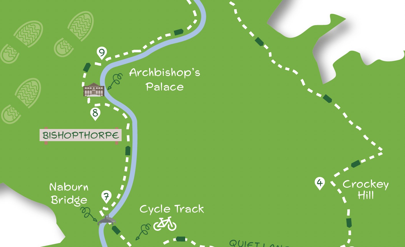
This almost entirely flat walk heads south from York Millennium Bridge, skirting Fulford to take tracks and a quiet lane to Naburn. From there, it crosses the River Ouse which is then followed, apart from a short stretch, all the way back to the starting point. The route is easy to navigate – the few points where it is possible to go astray are underlined in the Directions. Quite a lot of the route is on hard surfaces but some parts may be muddy especially between Direction points 2 and 3. The route should not be attempted when river levels are high. Care is needed when crossing the busy A19 at Crockey Hill.
Getting there
The recommended starting point is the Millennium Bridge. This can be accessed from either Butcher Terrace off Bishopthorpe Rd. or Maple Grove off Fulford Rd. Street parking is limited near the Millennium Bridge. If driving, consider starting from Fulford or Bishopthorpe. Bus route 11 from the city centre provides the most convenient public transport stopping on Bishopthorpe Rd. near Butcher Terrace.
Refreshments
At Bishopthorpe, both But First Café on Main Street and the Riverside Rest Café are en route. There are also several pubs on Main Street. At Naburn, both the Waterfront restaurant at the Marina and the Blacksmiths Arms in the village are just off-route.
What to see
There’s plenty of variety on this route: marshy areas beside the river, tree-lined tracks, a quiet country lane, a cycle track, the fisherman statue on Naburn bridge, the Ouse with its boat traffic, Bishopthorpe Palace and the Millennium Bridge.
1. Starting from the west side of the river at the end of Butcher Terrace, cross the Millennium Bridge. On the other side, fork half right across the grass on a beaten path to the tarmac cycle track. Turn right and ignore all ways off until a left bend, after which go right, passing a metal barrier with a wall to the left. Continue to join a road passing the original St Oswald’s Church (now a dwelling).
2. At the end of the churchyard, go over a road and head down a gravel track opposite. In about 100 metres, where the track bends sharp right, go left on a narrow path through vegetation with trees/gardens to left. Continue on this potentially muddy path, ignoring a way off left at a metal gate. At another gatekeep ahead (right) on a path which soon has a wall to the left. At a T junction, go left between fences then walk through a parking area to the main (A19) road.
3. Turn right crossing at a traffic island but before reaching traffic lights turn left into Fordlands Road. Almost immediately, cross another road and continue ahead with a recreation field to the right and cemetery to the left. Where the tarmac ends, keep ahead on a gravelled track (Forest Lane) then go over the bridge crossing the A64. At a farm keep the buildings on the left going ahead (not right towards A19). Eventually, reach a tarmac drive at which turn right towards the A19.
4. At the A19, cross with care and turn left along the grass verge. Almost at the traffic lights, there’s a ten-metre stretch of overgrown verge. Either forge through to reach a clearer area or cross back over the road and continue on the pavement opposite to re-cross road again at a traffic island. Continue on a roadside footway beside A19 with a wall to the right. Where the wall ends, turn right (Howden Lane).
5. Continue down this quiet lane. After about a mile, the road bends left before passing under an old railway bridge. About 15 metres beyond the bridge take a path right leading up to a cycle track.
6. Go left along the track soon crossing over a road (leave the cycle track here to visit Naburn and its refreshment facilities) and then the Ouse via the large metal bridge. About 100 metres beyond the river bridge go half right downslope but at the bottom double back right on a concrete slab path.
7. At metal gates go left on earth path to emerge beside the river. Now continue on the riverside path which soon passes numerous boat moorings. Ignore tracks off to the left eventually arriving at a camping area. As the track swings away from the river beyond a large building, keep right on a narrow riverside path with railings to left. Follow railings away from the river to reach a road leading to the end of Bishopthorpe’s Main Street (at the time of walking this last section of riverside path was closed. If not open, divert by staying with the track where it swings left passing a recreation field to arrive at a T junction. Here, turn right to the end of Bishopthorpe’s Main Street at which turn right).
8. Do not go down Main Street but bend right. Continue passing the entrance to Bishopthorpe Palace but several hundred metres beyond, opposite the end of a wall on left, take narrow earth footpath right between fences leading to the river.
9. At the river go left, soon passing under the A64 bridge. Beyond, continue beside the river, at first with trees on either side. After a stile, continue on a raised bank sweeping left with the river. After further stiles, ignore the tempting track across the field to the left to stay by the river until meeting a tarmac cycle track. Here, continue ahead beside the river on the tarmac to arrive back at the Millennium Bridge.


Add a comment