8 miles – 3¾ hours
This walk explores the undulating countryside west of Wetherby. Apart from one steep climb, gradients are modest. Most of the route is well surfaced, but the tracks at direction points 5 and 6 can be muddy. There are a couple of places where care is needed in following the directions – these are underlined.
What To See
There’s lots of variety on this walk. The attractive and mostly quiet countryside is a contrast to bustling Wetherby with its stone buildings clustered around the marketplace. There’s also the river Wharfe, a manicured golf course and the mansions of affluent Linton. Sicklinghall is an unspoilt stone village while Stockeld Park is a mix of stately grandeur and amusement park. The Harland Way cycle track provides a calm and easy route back to Wetherby.
Getting There
Wetherby is 14 miles from York using the B1224. The recommended starting point is Wetherby bus station. Bus 412 runs five times daily (not Sunday) from York Piccadilly and rail station. If driving, the easiest parking place is the Crossley street car park (free) by which the walk passes.
Refreshments
There are numerous pubs and cafes in Wetherby. On route only the Scotts Arms in Sicklinghall.
Directions
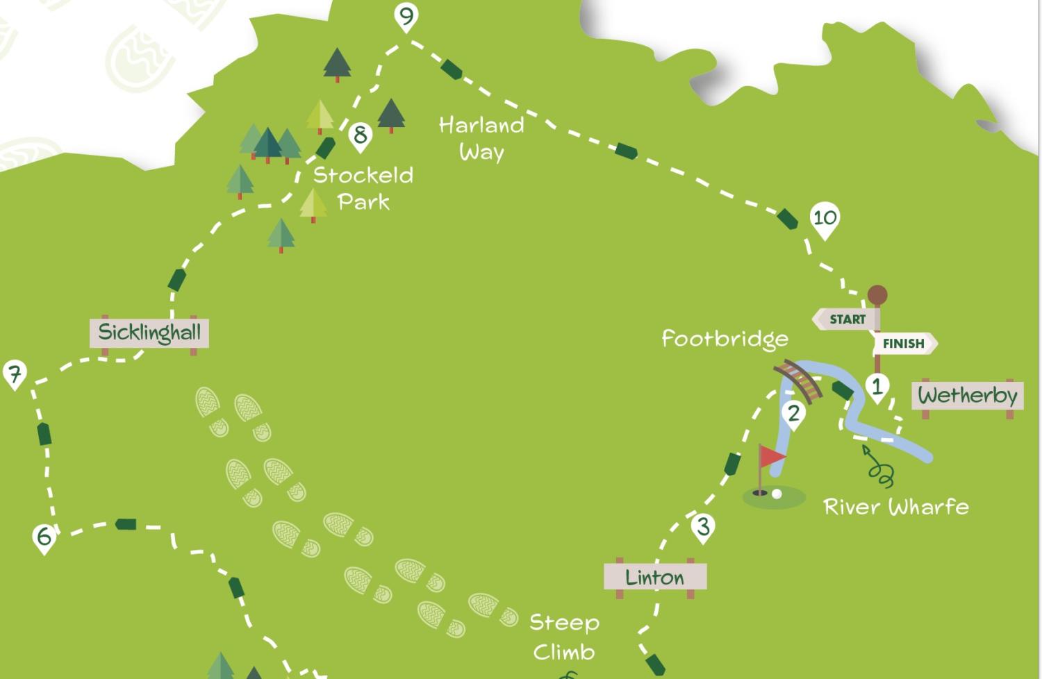
1/ Starting from the bus station entrance, turn right towards the mini roundabout (if starting from Crossley St. Car Park, take the alley alongside Hartlaw LLP) leading to the Market Place and bus station). Turn right at the roundabout and cross the river. Immediately over the bridge, turn right (Lodge Lane). At the leisure centre car park go right to the riverside footpath. Follow this as it bends left with the river to reach a footbridge.
2/ Cross the bridge. On the other side, go half left across grass with a playground right to a tarmac footpath in the tree avenue. Turn left on the path. Continue to a stone stile and head straight over the field to the fence gap. Go onto the golf course following markers across a track and fairway. Take a clear path through tall grass to a footpath sign pointing right. Go under the bridge then half left, crossing another fairway towards white signs. At these go up steps to a road.
3/ Cross the road and turn left, following the path/verge for 600 metres until the Memorial Hall on the left. Take the track on its right, following it through gates into a concreted area. Go through white gates and continue ahead on track which soon becomes tarmac leading back to the road left earlier.
4/ Cross the road into Linton Common opposite (ignore private road sign, it’s a public footpath). After the last house, take the signed footpath right, up steps. Climb the slope through trees to reach a tarmac lane. Turn left and continue for almost a kilometre to a hotel gateway.
5/ Go right on the signed path through trees to a field. Cross the field heading towards two large trees. Here go left then right to walk along the wood edge. Continue on the path which goes into trees, then has a narrow enclosed stretch with a field left. Keep ahead when the path widens bending left to reach a tarmac drive. Turn right but at a wooden gate take the bridleway (blue arrow) left heading along the edge of a field.
6/ Continue passing a wood to the left but at a wooden fence/metal hand gate turn right through the hedge gap into the corner of a field. Go ahead down the field with a hedge left. Continue ahead on what becomes a partly hedged track to a tarmac drive. Ignore Back Lane on the right to arrive at Sicklinghall’s main street.
7/ Turn right and continue through the village passing the pub, village hall and pond. Just after the pond leave the street left down Stockeld Lane (ignore no entry sign, it’s a public bridleway). Continue passing a lodge house and security gate. Stay on the now rougher surfaced lane walking through trees and then parkland. Do not go right towards Stockeld Park House but stay on the track which is joined by a tarmac drive from the house. At a meeting of tracks in a further 20 metres keep left, soon crossing a cattle grid, to continue down a tree avenue with the amusements area right. Exit the park by the lodge house.
8/ Cross the busy road with care and head down the track opposite. Where the track splits keep right of the open-sided barn then go through a metal gate following the path half left across a field. In the corner go through a gate and down hedged track to the Harland Way cycle route.
9/ Turn right and continue for nearly two kilometres ignoring crossing paths on the edge of Wetherby.
10/ Where the Harland Way forks in two at a grassy area go left but about 20 metres further on go right up a slope. At the bike barrier do not go ahead but turn right into a grassy area following a track along its edge beside trees. Soon merge with a surfaced track from the left but in 20 metres turn left through the bike barrier into a park taking the path between young trees. Exit the park through barriers and go left to a T junction. Turn right and head down the residential street (Barleyfields Road). Keep ahead where this narrows going through an alley leading to a road guarded by metal barriers. Cross the road (Crossley Street Car Park right) to continue down The Ginnel opposite. Soon arrive at Westgate. Turn left to the Market Square and bus station.


Add a comment