The chief feature of this easy and almost totally flat route is the usually tranquil River Derwent, the banks of which are followed for about four of the seven miles. Route finding is simple, and the paths good. Cattle may be grazing in the riverside fields north of Kexby. The walk will be impassable when the river is in flood.
Getting There
The recommended starting point is Stamford Bridge. The village is eight miles east of York on the A166. The main car park is immediately on the right after crossing the river bridge. The walk can also be started from Kexby where there’s limited parking off the main road to the right by the old bridge. Bus no. 10 from the railway station and city centre runs to Stamford Bridge every 30 minutes (less frequently on Sunday). Alight at the square. Buses 45, 46, X46 and X47 stop at Kexby Bridge.
Refreshments
There are several options in the centre of Stamford Bridge including two pubs, a wine bar and a café. Low Catton has the Gold Cup pub.
What To See
The normally sedate river and its wildlife is the main attraction. Birds spotted when the route was checked include kingfisher, reed warbler, egret and yellowhammer. Stamford Bridge is a busy village mainly famous for the eleventh-century battle. The now redundant railway viaduct is a popular walking and cycle route and affords good views over the river and surrounding countryside. Straggling Low Catton village has an ancient church in a secluded spot near the river.
Directions
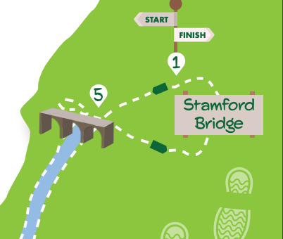
1/ Starting at the entrance to the car park in Stamford Bridge, take the signed footpath on the right (on the left if exiting the car park) going over the flood bank and down towards the riverside as directed by a yellow arrow. Go through a gate and continue beside the river towards the viaduct. After the viaduct, keep right by the river to go over a ditch on a plank bridge on the edge of grassy meadows. After a metal gate, the path goes slightly left away from the river. The way ahead is then obvious, first on a stoned track then along the right edge of fields. Beyond this, the path goes between a hedge and a wooded area, crosses a stream on a concrete bridge, passes through conifer trees and then skirts a large garden on the right. Eventually, it ends at a kissing gate giving access to a road on the edge of Low Catton.
2/ Turn right here to immediately go left around a bend into Low Catton (to visit the church take the path to the right at the bend). Pass the Gold Cup pub on the right and continue through the village. Keep on the quiet road until it turns sharply left. Here take the signed bridleway ahead on the right.
3/ Follow this across an open field on a dirt track. Where the track goes sharp right, continue ahead with a hedge to the left. Keep going as the track becomes grassy, passing through further gates with a hedge and soon, a pig farm to the left. Keep ahead at a further gate, now with a hedge on the right, to reach the main road.
4/ Go right on the pavement soon coming to the bridge over the river. Immediately over the bridge, look for a signed footpath on the right by the East Riding sign. Take this path, initially through tall vegetation, dropping down to the riverside. For the next three miles, the route follows the river on the right passing through a series of metal gates, some guarding bridges over ditches. About halfway along this stretch, there’s a stone bridge over a ditch in a hollow with a step over metal rails. When the houses of Stamford Bridge become visible across the river on the right the route passes through an area of rougher vegetation. Soon after this, there’s another stone-built bridge after which there’s a fenced path as the viaduct is again approached.
5/ Once under the viaduct do not continue alongside the river but go left on a path paralleling the old railway embankment to the left (for a slightly shorter return to Stamford Bridge keep on by the river). After about 150 metres climb the wooden steps set in the bank on the left to reach the tarmac cycle track. Here turn left, crossing the viaduct high above the river. Keep on through the old station to come to a road. Turn left here passing the school and church on the right. Follow the road as it bends left to arrive at the square in the centre of Stamford Bridge. Turn left to return to the bus stop and car park.


SallyAnn
08 Jul 2024 at 22:09An enjoyable walk however the path on the west/ York side of the river is very overgrown due to lack of use. Took longer than stated as a result.
Add a comment