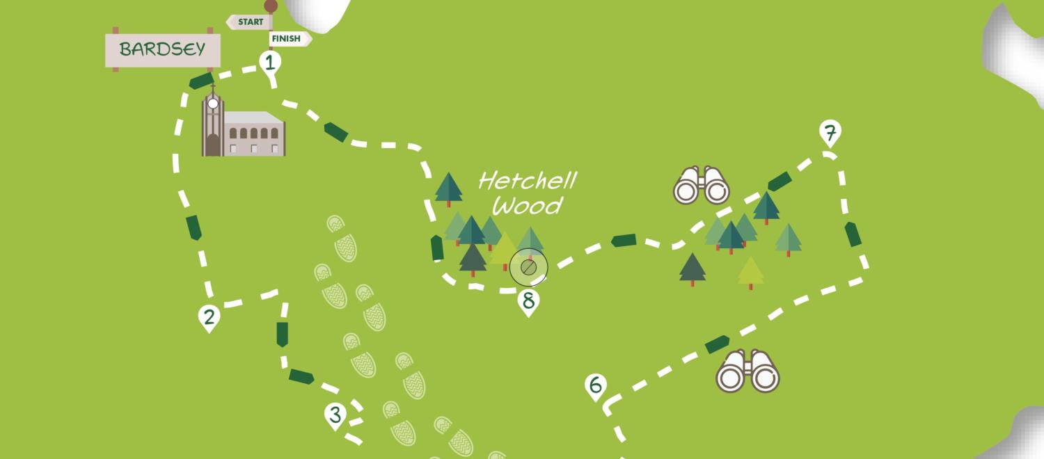
This walk of six and a half miles explores the countryside between Wetherby and the Northeast suburbs of Leeds, an area sometimes dubbed the ‘Yorkshire Cotswolds’. It includes an attractive mix of fields and woodland and the odd patch of suburbia. Near the end, there’s a short stretch through Yorkshire Wildlife Trust’s Hetchell Wood Nature Reserve which can be fully explored by turning right rather than left at Point 8 in the directions. The entire walk is on good paths which are generally well waymarked and easy to follow. There are a few points where care needs to be taken to avoid straying from the route – these are bold in the directions.
Getting there
The recommended starting point is the junction of the A58 (Wetherby Road) and Church Lane in Bardsey. An alternative starting point is Thorner. By car, Bardsey is 18 miles from York via the B1224 and A58. Roadside parking is possible on Church Lane or the suburban roads leading from it. Public transport to Bardsey is via bus 412 from York Piccadilly to Wetherby Bus Station (not Sundays) then changing to the X99. Alight at Bardsey Wetherby Road (Wood Lane). This stop is almost opposite the Church Lane junction starting point.
Refreshments
In Bardsey, further up Church Lane from the church, is the historic Bingley Arms. There are three pubs slightly off route in Thorner. These can be reached by going straight on (rather than down Station Lane) at Point 4 in the Directions. The nearest to the route is the Mexborough Arms.
What to see
The suburban houses of Bardsey belie the village’s ancient roots. The church tower dates from 850-900 and is said to be one of the oldest in the country. The nearby Bingley Arms also claims to be one of England’s oldest recorded pubs. Thorner is a large village with another ancient church. Stubbing Moor is an area of pleasant woodland. Hetchell Wood Nature Reserve is a mix of woodland and species-rich grassland. It also contains several crags popular with rock climbers. Nearby are the curious earthworks of Pompocali, thought to be Roman in origin.
Directions
- Starting from the junction of Church Lane with the A58 in Bardsey go up Church Lane to the church. Go into the churchyard and round the left of the church. Opposite the main door turn left through a gap in the wall and down an earth footpath to the right of the All Hallows Glade information board. Cross the beck and continue into the field keeping to the right edge, follow the path uphill with houses to the right. Near the top go right to join a hedged track at a 90° bend. Go left here following the track, which widens to pass houses left, before bending left to arrive at the main road.
2. Cross the road and go left for 30 metres to take the signed bridleway. You’ll pass derelict buildings to the left. At the end of the field be sure to go right up the field with its hedge to the left. Stay by the hedge to go down into trees to follow a path with a ditch, then ponds, to the right. Keep right at a prominent sign quickly crossing a footbridge then going up the left edge of a field to a track. Turn right passing houses on the left to a road.
3. Turn sharp left onto the road following it round some bends to a footpath sign on the right. Take the path across the field with a house away to the left to go through a gate. At the next gate turn left on the concrete track but in about 70 metres, at the edge of the last building on the right, go right through a hand gate as signed. Follow the path through trees and then between walls to the stile. Cross and head downhill through a field on an obvious grassy path. At the bottom pass through a metal kissing gate and go uphill on a fenced path crossing two stiles to a further kissing gate giving access to a track. Go down this to the road with Thorner’s Victory Hall to the right.
3. Turn left but do not go right with the main road. Instead, keep ahead down Station Lane going under the old railway bridge. Immediately beyond this go right on a narrow fenced path which bends left to emerge on a road opposite Thorner church. Turn left, but where the main road soon swings right keep left down Milner Lane. Continue on for 300 metres until just beyond the entrance to The Hawthorns. Here take the steps going up the bank on the right side of the road.
4. Go through the gate at the top of the steps to head half left in the field to a telegraph pole. Continue to find a stile to the left of the next pole. Now go straight ahead on a ‘shelf’ in the grassy field with a bank to the right and soon bushes on the left. Nearing the end of the long field do not swing up to the right but take an indistinct path ahead to a stile near the field’s left corner. Climb the stile and go into the wood to cross a footbridge.
5. Continue uphill to emerge in a field. Follow its left edge to a gate leading to an unmade lane.
6. Go right here continuing between hedges. Eventually, about 200 metres beyond a building, turn left on a bridleway between wooden fences (not straight ahead). Follow this toward the right edge of the wood ahead. At the corner of the wood, ignore a track joining from the right but in 20 metres turn left off the track at a bridleway sign into the trees.
7. The route now continues on the bridleway just inside the right-hand edge of the wood (Stubbing Moor Plantation) ignoring all paths off to the left. After about 800 metres the bridleway exits the wood into a field. Keep the hedge to the left to pass through a gap into the next field. Continue along its left edge to a gate giving access to a tarmac road.
8. Turn left but in five metres go down a bridleway with a fence and trees (Hetchell Wood) to the right (to access the top part of Hetchell Wood turn right). Keep on going downhill (to the left are the earthworks of Pompocali) to arrive at a bridge across a stream. Do not cross but go right just before it through a wooden kissing gate. Follow the path with a bank then a crag to the right through the bottom of the wood. Leave the wood through a kissing gate and pass a small pond to the right. Continue with a sloping field to the right and trees and stream to the left. Ignore a path coming in from the right bending left along the edge of the next field. At the field’s end, continue into the wood ignoring ways to the left. At a fork go right soon with the main road visible down the bank to the left. Continue then drop steeply down the bank onto the main road opposite Church Lane.
DISCLAIMER: Walks are undertaken at your own risk.
Due care must be taken in following the walk, particularly after poor weather. Whilst every care is taken in compiling the description changes may have occurred since publication. Neither the walk author nor Your Local Link can accept any responsibility for errors or omissions.


Add a comment