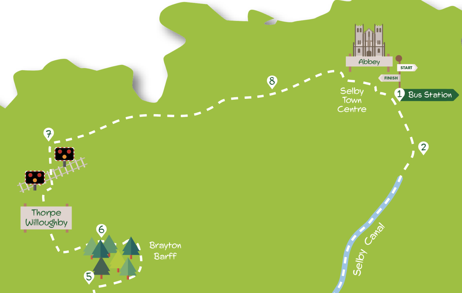
This is a walk of just over eight miles exploring some of the countryside to the south and west of Selby. Leaving Selby the route follows the towpath of the Selby canal before heading north to the woodland of Brayton Barff. From here a quick traverse of Thorpe Willoughby’s suburbia leads to an easy path through farmland back to the centre of Selby. Although there are a few muddier stretches much of this walk is on hard surfaces making it a good winter option. Route finding is generally straightforward except at Brayton Barff and in Selby town centre. Areas where special attention is required are underlined in the Directions.
What to see
Selby’s main attraction is its ancient Abbey open to visitors daily from 9am-4pm. Founded in 1069, notable features are the Norman nave and ‘decorated’ chancel. The Selby Canal linking the Ouse to the Aire at West Haddlesey was opened in 1778 and remains navigable. 52 metre high Brayton Barff and its neighbour Hambleton Hough to the west are isolated hillocks in an otherwise flat landscape. Owned by Yorkshire Water and with a covered reservoir at its top, the Barff is mainly covered with oak woodland managed for wildlife. There’s a fine display of bluebells in spring. A popular circular walk, much of which is traversed here, leads around the site.
Getting there
The walk starts from Selby bus station. Bus 415 departs at 15 minute intervals from York Piccadilly to Selby during the day Monday to Saturday (every 30 minutes on Sunday) taking approximately 45 minutes. There is also a train service from York to Selby taking about 30 minutes. If driving Selby is 14 miles south of York via the A19. Long stay parking is available in Back Micklegate and Portholme Road car parks. An alternative is to park on the street in Thorpe Willoughby and begin the walk
from there.
- Starting at Selby bus station (the rail station is a few minutes away) go left on the main (Bawtry) road crossing the obvious bridge. Continue until Canal Road joins on the left. Here join the canal towpath going right.
- The route now follows the towpath for over three miles to Burton Hall Bridge. In more detail: go under several bridges then come to a stile and parking area at Brayton Bridge; cross the road here and carry on passing a picnic bench to keep with the towpath; continue under a road bridge then go through another parking area and under a further road bridge; continue on the now grassed towpath path to another bridge (Burton Hall Bridge) with Drax power station clearly visible to the left and a deep ditch to the right.
- Turn right here off the towpath onto a car-wide track between hedges. Continue in the same direction as the surface becomes tarmac. At the top of the rise go through a gate to a road.
- Cross the road and follow the footpath to the right signposted Selby Horseshoe. The path swings left away from the road going gradually uphill to eventually arrive at a junction. Go left here with a road below on the right to arrive at a bridge.
- Cross the road bridge. On the other side swing left with the path but in ten yards at a junction turn sharp right up a slope. About 100 metres further on look out for a gap in the fence (‘No Fires Allowed’ sign). Through the gap turn almost immediately right following a sometimes indistinct path through the trees running parallel to a fence away to the right. Eventually this path comes to a wider and harder track where you go right. Continue on this with a fence and then a young hedge to the right and views across fields to Selby. Keeping the hill to the left the track leads to a car park. Here partly double back going through a gap by the metal gate on a clear track uphill. Keep on this as it twists right, the hill still to the left, until you eventually drop down to an exit from the woodland at a road.
- Cross the road and turn left on the roadside pavement (the bridleway directly opposite is currently closed). Ignore the first road on the right but turn into the second (Fox Lane). Continue along this straight road passing a few shops to a busy road by the Fox pub. Turn right but after 150 metres turn left down Dam Lane going over a level crossing. Continue on this road (no pavement so take care) over a narrow bridge to find a footpath on the right signed ‘Selby Horseshoe’.
- Follow the footpath with a hedge to the left eventually reaching a squeeze stile. Beyond this continue with hedges on each side to emerge onto a car wide track. Go along this passing a farm until the track joins a tarmac lane where you keep right towards Selby. Soon houses start on the left and you arrive at a road junction by a playground.
- Turn right here and keep straight on at a mini roundabout by a school. At the next mini roundabout turn right into Scott Road. After 75 metres go left, round to the rear of the Selby Community Centre and in front of the Scott Road Pharmacy. Go along the paved path across the grassy area with playground and then a pond on the right to the car park ahead. In the car park make toward the Sainsbury’s store, passing it and Wilco on the left to go down Abbey Walk. Cross straight over a road to a wide alley that leads onto Finkle Street. Turn right here to the Market Place, then left toward the Abbey. At the traffic lights by the Abbey cross to head right back to the bus station.
DISCLAIMER: Walks are undertaken at your own risk. Due care must be taken in following the walk, particularly after poor weather. Whilst every care is taken in compiling the description changes may have occurred since publication. Neither the walk author nor Your Local Link can accept any responsibility for errors or omissions.


Add a comment